IMAGES TAKEN NEAR TO
Rhoslefain, TYWYN, LL36 9NB
Introduction
This page details the photographs taken nearby to LL36 9NB by members of the Geograph project.
The Geograph project started in 2005 with the aim of publishing, organising and preserving representative images for every square kilometre of Great Britain, Ireland and the Isle of Man.

There are currently over 7.5m images from over14,400 individuals and you can help contribute to the project by visiting https://www.geograph.org.uk
Image Map (9 Images)


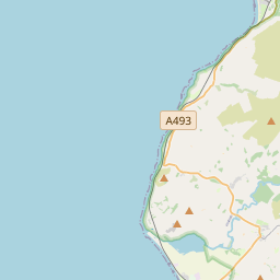


Leaflet Map data © OpenStreetMap
Images are licensed for reuse under creativecommons.org/licenses/by-sa/2.0
Notes
- Clicking on the map will re-center to the selected point.
- The higher the marker number, the further away the image location is from the centre of the postcode.
Image Listing (9 Images Found)
Images are licensed for reuse under creativecommons.org/licenses/by-sa/2.0
Image
Details
Distance
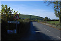
1
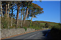
The A493 by Hafdy
With some nice trees in the property overlooking the road.
Image: © Nigel Brown
Taken: 25 Oct 2010
0.18 miles
3
Eastern approach to Rhoslefain
The A493 is fairly enclosed by stone walls here, which makes little room for pedestrians.
Image: © Nigel Brown
Taken: 25 Oct 2010
0.20 miles
4
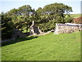
Pant Afal.
Unfortunately, yet another ruined farm.
Image: © Hefin Richards
Taken: 16 Sep 2006
0.21 miles
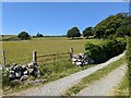
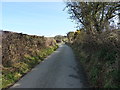
5
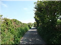
The lane to Gwastad Meirionydd
Big hedges and trees line this lane.
Image: © John Haynes
Taken: 21 May 2012
0.21 miles
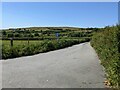
7
Bottom of the hill lane to Llwngwril
A narrow lane that crosses the hill of Pant Gwyn, giving access to a large area of rough grazings and marshy fields.
Image: © Richard Law
Taken: 4 Mar 2014
0.23 miles
8
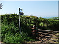
New gate and signage
The Wales Coast Path has had funding to improve the paths on the route.
http://www.ccgc.gov.uk/enjoying-the-country/wales-coast-path.aspx?lang=cy-gb
http://www.ccw.gov.uk/enjoying-the-country/wales-coast-path.aspx?lang=en
Image: © John Haynes
Taken: 21 May 2012
0.23 miles
9
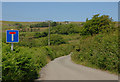
Dead-end road
Mainly the access to Perllan.
Image: © Nigel Brown
Taken: 22 Jun 2010
0.23 miles