IMAGES TAKEN NEAR TO
Bryn Mair, TYWYN, LL36 9AG
Introduction
This page details the photographs taken nearby to Bryn Mair, LL36 9AG by members of the Geograph project.
The Geograph project started in 2005 with the aim of publishing, organising and preserving representative images for every square kilometre of Great Britain, Ireland and the Isle of Man.

There are currently over 7.5m images from over14,400 individuals and you can help contribute to the project by visiting https://www.geograph.org.uk
Image Map (Loading...)


Getting Data...Please wait
Leaflet Map data © OpenStreetMap
Images are licensed for reuse under creativecommons.org/licenses/by-sa/2.0
Notes
- Clicking on the map will re-center to the selected point.
- The higher the marker number, the further away the image location is from the centre of the postcode.
Image Listing (221 Images Found)
Images are licensed for reuse under creativecommons.org/licenses/by-sa/2.0
Image
Details
Distance
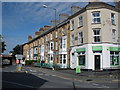
1
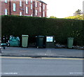
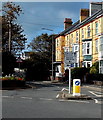
Shades of green in front of an Idris Villas hedge, Tywyn
On the west side of the street named Idris Villas, near the corner of High Street.
The large label on the telecoms cabinet between wheelie bins states
that superfast fibre broadband is here, funded by the Welsh Government.
Image: © Jaggery
Taken: 22 Oct 2016
0.01 miles
2
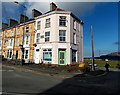
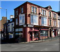
Late Victorian corner building in Tywyn
Viewed from the corner of High Street and Station Road.
The stone tablet between first floor windows on the corner building shows BRYNMAIR 1892.
Image: © Jaggery
Taken: 22 Oct 2016
0.01 miles
3

Bryn Awel Square houses, Tywyn
Viewed from Tywyn railway station.
Image: © Jaggery
Taken: 22 Oct 2016
0.01 miles
4
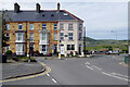
Bryn Awel Square, Tywyn
The Victorian terrace ahead is on Bryn Awel Square; in the foreground is Station Road and on the immediate left is the entrance to the station car park. The A493 takes a right angled turn into the town centre.
Image: © Stephen McKay
Taken: 15 Jun 2022
0.01 miles
5
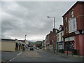
Part of the main street in Tywyn
A fairly typical seaside town main drag, but lots to see and lots of interest.
Image: © Jeremy Bolwell
Taken: 19 May 2012
0.01 miles
6
Bilingual directions sign facing High Street, Tywyn
The Welsh/English directions show ahead for Glan y môr/Sea front or left for Aberdyfi/Aberdovey.
Image: © Jaggery
Taken: 22 Oct 2016
0.01 miles
7
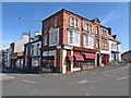
Corner Shop in Tywyn
Welsh for Corner Shop, Siop-y-Gornel is on the corner of High Street and Station Road.
Image: © Jaggery
Taken: 22 Oct 2016
0.02 miles
8
Tywyn High Street
Off Licence on the corner of Station Road.
Image: © Ian Rob
Taken: 13 Sep 2019
0.02 miles
9
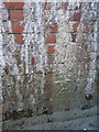
OS benchmark - Tywyn, railway bridge, Bryn Awel Square
An OS cutmark in the brick abutment of the railway bridge immediately north of the station. As the photo shows, it's in danger of being lost to creeping limescale deposition. Originally levelled at 7.765m above Ordnance Datum Newlyn.
Image: © Richard Law
Taken: 25 Nov 2013
0.02 miles