IMAGES TAKEN NEAR TO
Terrace Road, ABERDOVEY, LL35 0LU
Introduction
This page details the photographs taken nearby to Terrace Road, LL35 0LU by members of the Geograph project.
The Geograph project started in 2005 with the aim of publishing, organising and preserving representative images for every square kilometre of Great Britain, Ireland and the Isle of Man.

There are currently over 7.5m images from over14,400 individuals and you can help contribute to the project by visiting https://www.geograph.org.uk
Image Map (Loading...)


Getting Data...Please wait
Leaflet Map data © OpenStreetMap
Images are licensed for reuse under creativecommons.org/licenses/by-sa/2.0
Notes
- Clicking on the map will re-center to the selected point.
- The higher the marker number, the further away the image location is from the centre of the postcode.
Image Listing (125 Images Found)
Images are licensed for reuse under creativecommons.org/licenses/by-sa/2.0
Image
Details
Distance
1
Corner of Terrace Road and Nantiestyn, Penhelig, Aberdovey
Nantiestyn on the right ascends from the corner of the A493 and Terrace Road.
Image: © Jaggery
Taken: 17 Oct 2016
0.01 miles
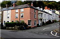
2
Terraced housing in Penhelig
Viewed from the railway station.
Image: © John Lucas
Taken: 10 Jul 2006
0.01 miles
3
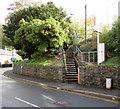
Steps up to Penhelig railway station
From the A493 Terrace Road. These steps are the only way into or out of the station.
The nearest accessible station for wheelchair users is Aberdovey, about a mile (c1.6km) to the west.
Image: © Jaggery
Taken: 17 Oct 2016
0.01 miles
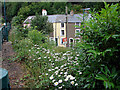
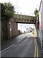
5
The rail bridge at Penhelig
The station is beyond the bridge, to the right. The Penhelig Arms on the left looked very inviting after an 8 mile walk over the hills, but with only 10 mins. to my train (and not another one for 2 hours) I had to wait for my pint!
Image: © John Lucas
Taken: 5 Jul 2016
0.01 miles
6
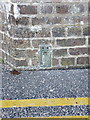
OS Flush Bracket S0346 - Penhelig railway bridge
An OS flush bracket low down on the wall on the north side of the A493, at the base of the railway bridge right next to the Penhelig Arms hotel. Originally levelled at 5.629m above Ordnance Datum Newlyn.
Image: © Richard Law
Taken: 25 Nov 2013
0.01 miles
7
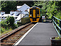
A Birmingham bound train arriving at Penhelig
Will combine with the Aberystwyth section at Machynlleth. Cambrian unit 158841.
Image: © John Lucas
Taken: 5 Jul 2016
0.01 miles

9
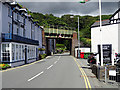
North side of a railway bridge, Penhelig, Aberdovey
Immediately west of Penhelig railway station, the Cambrian Coast Line
crosses above the A493 Terrace Road. Headroom shown is 15' 9".
Image: © Jaggery
Taken: 17 Oct 2016
0.02 miles
10
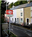
Penhelyg/Penhelig railway station name sign
Facing the A493 Terrace Road, alongside the station entrance steps. http://www.geograph.org.uk/photo/5349689
Image: © Jaggery
Taken: 17 Oct 2016
0.02 miles