IMAGES TAKEN NEAR TO
Glan Y Coed Park, PENMAENMAWR, LL34 6TL
Introduction
This page details the photographs taken nearby to Glan Y Coed Park, LL34 6TL by members of the Geograph project.
The Geograph project started in 2005 with the aim of publishing, organising and preserving representative images for every square kilometre of Great Britain, Ireland and the Isle of Man.

There are currently over 7.5m images from over14,400 individuals and you can help contribute to the project by visiting https://www.geograph.org.uk
Image Map
Images are licensed for reuse under creativecommons.org/licenses/by-sa/2.0
Notes
- Clicking on the map will re-center to the selected point.
- The higher the marker number, the further away the image location is from the centre of the postcode.
Image Listing (15 Images Found)
Images are licensed for reuse under creativecommons.org/licenses/by-sa/2.0
Image
Details
Distance
1
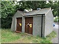
Old Mill Road substation, Dwygyfylchi
See also Image
Image: © Meirion
Taken: 30 Jul 2024
0.13 miles
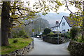
3
Bridge, Afon Gyrach
Small bridge affording (narrow) road access to the cottages beyond Old Mill Road.
Image: © Jonathan Wilkins
Taken: 26 Aug 2011
0.13 miles
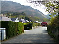
5
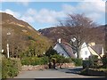
Old Mill Road
Note the ornate lamp post, which is typical of many in the Penmaenmawr area.
Image: © Ceri Thomas
Taken: 25 Apr 2010
0.16 miles
6
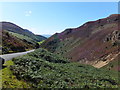
Sychnant Pass
The heather is just starting to come into bloom.
The dark image on the horizon is Ynys Mon - Isle of Anglesey.
Image: © Richard Hoare
Taken: 18 Aug 2012
0.16 miles
7
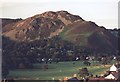
Penmaenmawr Golf Course & Alltwen
Looking East North East from 'Foel Lus' (meaning Bilberry Hill) towards 'Alltwen' a hilltop fort (meaning White Cliff) across Penmaenmawr Golf Course.
Image: © Stephen Elwyn RODDICK
Taken: Unknown
0.17 miles
8
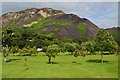
Penmanmawr Golf Course, view towards Allt Wen
Image: © David Martin
Taken: 7 Aug 2016
0.19 miles
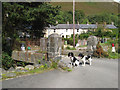
10
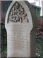
Sloane grave
The grave of John and Elizabeth SLOANE, is located at the rear of St. Gwynin's Church in Dwygyfylchi, Penmaenmawr.
John was killed on Christmas Eve 1880 when he fell under the wheels, when getting off the train at Penmaenmawr Station. His wife Elizabeth died on her wedding Anniversary 29 October 1883, at the Chapel where she was married, during a service. There were 6 children left without a mother and father, all survived into adulthood. The dates on the headstone for John and Elizabeth are incorrect.
Image: © BrianPritchard
Taken: 31 Aug 2011
0.22 miles