IMAGES TAKEN NEAR TO
Treforris Road, PENMAENMAWR, LL34 6RA
Introduction
This page details the photographs taken nearby to Treforris Road, LL34 6RA by members of the Geograph project.
The Geograph project started in 2005 with the aim of publishing, organising and preserving representative images for every square kilometre of Great Britain, Ireland and the Isle of Man.

There are currently over 7.5m images from over14,400 individuals and you can help contribute to the project by visiting https://www.geograph.org.uk
Image Map
Images are licensed for reuse under creativecommons.org/licenses/by-sa/2.0
Notes
- Clicking on the map will re-center to the selected point.
- The higher the marker number, the further away the image location is from the centre of the postcode.
Image Listing (22 Images Found)
Images are licensed for reuse under creativecommons.org/licenses/by-sa/2.0
Image
Details
Distance
1
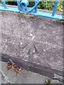
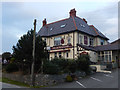
Rivet benchmark on Treforris Road, Dwygyfylchi
This rivet benchmark is located on the low boundary wall of the school on Treforris Road in Dwygyfylchgi and it is shown in the current Ordnance Survey database at a height of 57.4761m above the Newlyn datum.
Image: © Meirion
Taken: 21 Aug 2011
0.01 miles
2
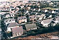
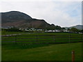
Dwygyfylchi from above Capel Horeb
Looking down on Dwygyfylchi from the hillside behind Capel Horeb.
Image: © Stephen Elwyn RODDICK
Taken: Unknown
0.05 miles
4
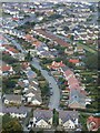
Toeau amryliw yn Nwygyfylchi / Multi-coloured roofs in Dwygyfylchi
Image: © Ceri Thomas
Taken: 6 Oct 2012
0.05 miles
5
Tyddyn Du touring Caravan Park, Dwygyfylchi
The mountain in the background if Foel Lus.
Image: © Eirian Evans
Taken: 24 Apr 2009
0.11 miles
6
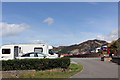
Tyddyn Du Touring Park Conway Old Road Penmaenmawr
Image: © Jo and Steve Turner
Taken: 18 Jun 2011
0.12 miles
7
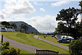
Tyddyn Du Touring Park Conway Old Road Penmaenmawr
Image: © Jo and Steve Turner
Taken: 18 Jun 2011
0.16 miles
8
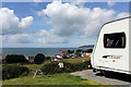
Tyddyn Du Touring Park Conway Old Road Penmaenmawr
Image: © Jo and Steve Turner
Taken: 18 Jun 2011
0.18 miles
9
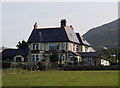
The Gladstone on Ysguborwen Road, Dwygyfylchi
Taken from the Wales Coast Path.
Image: © Ian S
Taken: 17 Sep 2014
0.19 miles
10
The Gladstone, Dwygyfylchi
This pub on Ysgubor Wen Road, between Dwygyfylchi village and Penmaenmawr, is named after the Victorian prime minister who regularly spent holidays in this area.
Image: © Stephen McKay
Taken: 23 Sep 2017
0.19 miles