IMAGES TAKEN NEAR TO
Crimea Terrace, PENMAENMAWR, LL34 6NL
Introduction
This page details the photographs taken nearby to Crimea Terrace, LL34 6NL by members of the Geograph project.
The Geograph project started in 2005 with the aim of publishing, organising and preserving representative images for every square kilometre of Great Britain, Ireland and the Isle of Man.

There are currently over 7.5m images from over14,400 individuals and you can help contribute to the project by visiting https://www.geograph.org.uk
Image Map
Images are licensed for reuse under creativecommons.org/licenses/by-sa/2.0
Notes
- Clicking on the map will re-center to the selected point.
- The higher the marker number, the further away the image location is from the centre of the postcode.
Image Listing (80 Images Found)
Images are licensed for reuse under creativecommons.org/licenses/by-sa/2.0
Image
Details
Distance

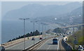
4
The A55 North Wales Expressway
Taken from the Wales Coast Path
Image: © Ian S
Taken: 17 Sep 2014
0.04 miles
6
A55 and rail line at Penmaenan
Taken from the Wales Coast Path.
Image: © Ian S
Taken: 17 Sep 2014
0.04 miles
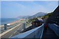
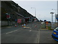
7
The A55 North Wales Expressway at Penmaenmawr
Image: © Mat Fascione
Taken: 17 Apr 2019
0.05 miles
8
Approaching Pen-y-Clip tunnel
The A55 westwards goes through the Pen-y-Clip tunnel at Penmaenmawr which is currently closed for repairs, so all traffic is going via the east-bound carriageway which hugs the cliffside.
Image: © Eirian Evans
Taken: 6 Mar 2012
0.05 miles
9
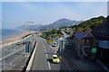
The A55 North Wales Expressway
Taken from the Wales Coast Path.
Image: © Ian S
Taken: 17 Sep 2014
0.05 miles
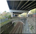
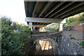
10
Crimea incline
This pair of self-acting inclines was the route followed by all of the products from Brundrit's quarrying. In later years extensive storage hoppers were constructed above the Penmaen Jetty and conveyor belts replaced the tramways on the jetty, but it was always a boast that ships could be loaded with crushed rock on both sides of the jetty simultaneously. Close examination is required to find any evidence of this furious activity today, and the A55 Expressway runs over the site of the storage hoppers on a significant viaduct. Closure of Wright's rail sidings and jetty in 1952 meant the closure of these inclines as well - all traffic being routed via Bell Yard from this time.
Image: © Jonathan Wilkins
Taken: 24 Aug 2014
0.05 miles