IMAGES TAKEN NEAR TO
Bangor Road, PENMAENMAWR, LL34 6LF
Introduction
This page details the photographs taken nearby to Bangor Road, LL34 6LF by members of the Geograph project.
The Geograph project started in 2005 with the aim of publishing, organising and preserving representative images for every square kilometre of Great Britain, Ireland and the Isle of Man.

There are currently over 7.5m images from over14,400 individuals and you can help contribute to the project by visiting https://www.geograph.org.uk
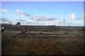
Image Map
Images are licensed for reuse under creativecommons.org/licenses/by-sa/2.0
Notes
- Clicking on the map will re-center to the selected point.
- The higher the marker number, the further away the image location is from the centre of the postcode.
Image Listing (95 Images Found)
Images are licensed for reuse under creativecommons.org/licenses/by-sa/2.0
Image
Details
Distance
2
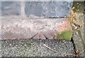
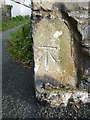
Ordnance Survey Cut Mark
This OS cut mark can be found on the wall south side of Esplanade. It marks a point 24.707m above mean sea level.
Image: © Adrian Dust
Taken: 26 Oct 2018
0.04 miles
4
Ordnance Survey Rivet
This damaged OS rivet can be found on the south side of Bangor Road. It marks a point 38.374m above mean sea level.
Image: © Adrian Dust
Taken: 26 Oct 2018
0.07 miles
6
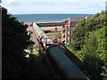
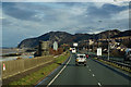
Rail loading facility
When the by-pass was built, all the original bunkers and conveyers that were used for loading trains with the rock produced from the quarry were demolished and replaced. The new loading facility was much smaller and could only load trains on one siding - most of the space of the original sidings having been taken up by the new road. It is a sad reflection on our current times that the quarry is now mothballed as a consequence of losing the contract to supply railway ballast to Network Rail - a feature of the town for almost 100 years.
Image: © Jonathan Wilkins
Taken: 21 Aug 2009
0.08 miles
7
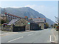
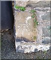
Benchmark on St. David's Road, Penmaenmawr
This benchmark is located on the E side of St. David's Road in Penmaenmawr & it is shown in the current Ordnance Survey database at a height of 33.1958m above the Newlyn datum.
Image: © Meirion
Taken: 8 Nov 2010
0.09 miles
8
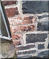
Ordnance Survey Cut Mark
This OS cut mark can be found on the wall east side of St David's Road. It marks a point 33.196m above mean sea level.
Image: © Adrian Dust
Taken: 26 Oct 2018
0.09 miles