IMAGES TAKEN NEAR TO
Conway Old Road, PENMAENMAWR, LL34 6EH
Introduction
This page details the photographs taken nearby to Conway Old Road, LL34 6EH by members of the Geograph project.
The Geograph project started in 2005 with the aim of publishing, organising and preserving representative images for every square kilometre of Great Britain, Ireland and the Isle of Man.

There are currently over 7.5m images from over14,400 individuals and you can help contribute to the project by visiting https://www.geograph.org.uk
Image Map (Loading...)


Getting Data...Please wait
Leaflet Map data © OpenStreetMap
Images are licensed for reuse under creativecommons.org/licenses/by-sa/2.0
Notes
- Clicking on the map will re-center to the selected point.
- The higher the marker number, the further away the image location is from the centre of the postcode.
Image Listing (49 Images Found)
Images are licensed for reuse under creativecommons.org/licenses/by-sa/2.0
Image
Details
Distance
1
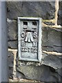
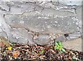
Flush bracket G2772 on St. Seiriol's Church, Penmaenmawr
This flush bracket located on the SE face of St. Seiriol's Church in Penmaenmawr is shown in the Ordnance Survey database as being 46.2037m above the Newlyn datum. See also: Image
Image: © Meirion
Taken: 8 Nov 2010
0.05 miles
2
Ordnance Survey Flush Bracket (G2772)
This OS Flush Bracket can be found on the SE face of St Seiriol's Church. It marks a point 46.204m above mean sea level.
Image: © Adrian Dust
Taken: 26 Oct 2018
0.05 miles
3
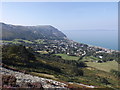
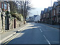
Penmaenmawr from Victoria walk
Penmaenmawr from Victoria walk at the top of mountain road.
Image: © Garry Lavender-Rimmer
Taken: 10 Sep 2014
0.06 miles
4
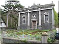
Calvinist Methodist chapel
A long-disused chapel with a curious history. According to the listing by CADW (grade II, no. 16516) the building was originally (1867) a Calvinist Methodist chapel, but was subsequently converted into the Roman Catholic Church of the Lady of the Rosary during the 20th century. The listing is on the merit of its "well-balanced facade", which is executed in an ionic-styled pale limestone in contrast to the locally-quarried microdiorite, which is dark grey.
Image: © Jonathan Wilkins
Taken: 26 Feb 2016
0.07 miles
5
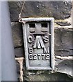
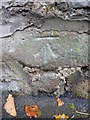
Ordnance Survey Cut Mark
This OS cut mark can be found on the wall SE side of Conway Old Road. It marks a point 45.615m above mean sea level.
Image: © Adrian Dust
Taken: 26 Oct 2018
0.07 miles
6
Benchmark on Conwy Old Road, Penmaenmawr
This benchmark is located on SE side of Conwy Old Road (Ffordd Hen Conwy) & it is shown in the current Ordnance Survey database at a height of 45.6151m above the Newlyn datum.
Image: © Meirion
Taken: 8 Nov 2010
0.07 miles
7
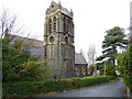
St. Seiriol's Church, Penmaenmawr
Built to a design by the architect Alfred Waterhouse the foundation stone for St. Seiriol's Church was laid in 1867. The bell of the Church was donated by the prime minister William E Gladstone in 1885. See also: Image
Image: © Meirion
Taken: 8 Nov 2010
0.08 miles
8
Graiglwyd Road 2
Looking down the hill at the eastern end of the road, showing Ysgol Pencae.
Image: © Jonathan Wilkins
Taken: 26 Feb 2016
0.10 miles
10
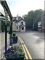
Mountain View Hotel, Penmaenmawr
On the junction of Bangor Road and Conwy Old Road.
Image: © Eirian Evans
Taken: 24 Apr 2009
0.14 miles