IMAGES TAKEN NEAR TO
Nant Y Felin Road, LLANFAIRFECHAN, LL33 0SY
Introduction
This page details the photographs taken nearby to Nant Y Felin Road, LL33 0SY by members of the Geograph project.
The Geograph project started in 2005 with the aim of publishing, organising and preserving representative images for every square kilometre of Great Britain, Ireland and the Isle of Man.

There are currently over 7.5m images from over14,400 individuals and you can help contribute to the project by visiting https://www.geograph.org.uk
Image Map (Loading...)


Getting Data...Please wait
Leaflet Map data © OpenStreetMap
Images are licensed for reuse under creativecommons.org/licenses/by-sa/2.0
Notes
- Clicking on the map will re-center to the selected point.
- The higher the marker number, the further away the image location is from the centre of the postcode.
Image Listing (19 Images Found)
Images are licensed for reuse under creativecommons.org/licenses/by-sa/2.0
Image
Details
Distance
1
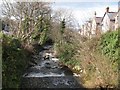
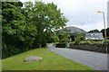
Afon Llanfairfechan
The upper town ascends the steep valley of the Afon Llanfairfechan with a road on each bank. Here, Nantyfelin Road crosses a bridge to reach Valley Road on the eastern bank. The riverbed is strewn with large, glacially-derived boulders and the sound of the rushing water fills the valley.
Image: © Jonathan Wilkins
Taken: 7 Mar 2014
0.03 miles
2
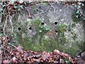
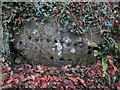
Terrace Walk rock cannon No. 2, Llanfairfechan
One of two rock cannon in close proximity just off Terrace walk in Llanfairfechan. This rock cannon has 8 holes in total.
Image: © Meirion
Taken: 8 Jan 2017
0.06 miles
3
Terrace Walk rock cannon, Llanfairfechan
One of two rock cannon in close proximity just off Terrace walk in Llanfairfechan. This rock cannon has 18 holes in total.
Image: © Meirion
Taken: 8 Jan 2017
0.06 miles
4
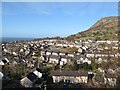
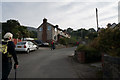
Valley view
A view over Valley Road from Terrace Walk, with the crag of Penmaen Mawr in the right distance.
Image: © Jonathan Wilkins
Taken: 7 Mar 2014
0.09 miles
5
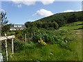
Looking towards Garreg Fawr
From the minor road at Nant-y-felin.
Image: © David Medcalf
Taken: 17 Aug 2019
0.09 miles
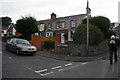
6
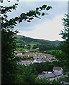
Cae America & Valley Road, Llanfairfechan
This photo was taken from near the golf course.
Image: © Ceri Thomas
Taken: Unknown
0.10 miles
7
The Terrace Walk leads to the North Wales Path
Image: © Ian Greig
Taken: 10 Jul 2010
0.11 miles
8
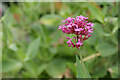
Red Valerian (Cetranthus ruber)
A helpful Geograph member identified this flower for me and provided this link:
http://www.floralimages.co.uk/pcentrruber.htm
Image: © Ian Greig
Taken: 10 Jul 2010
0.13 miles