IMAGES TAKEN NEAR TO
Upper Mill Road, LLANFAIRFECHAN, LL33 0SL
Introduction
This page details the photographs taken nearby to Upper Mill Road, LL33 0SL by members of the Geograph project.
The Geograph project started in 2005 with the aim of publishing, organising and preserving representative images for every square kilometre of Great Britain, Ireland and the Isle of Man.

There are currently over 7.5m images from over14,400 individuals and you can help contribute to the project by visiting https://www.geograph.org.uk
Image Map (Loading...)


Getting Data...Please wait
Leaflet Map data © OpenStreetMap
Images are licensed for reuse under creativecommons.org/licenses/by-sa/2.0
Notes
- Clicking on the map will re-center to the selected point.
- The higher the marker number, the further away the image location is from the centre of the postcode.
Image Listing (41 Images Found)
Images are licensed for reuse under creativecommons.org/licenses/by-sa/2.0
Image
Details
Distance
1
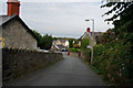
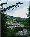
Valley view
A view over Valley Road from Terrace Walk, with the crag of Penmaen Mawr in the right distance.
Image: © Jonathan Wilkins
Taken: 7 Mar 2014
0.04 miles
3

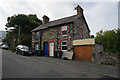
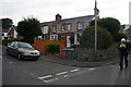
Houses, Valley Road
The heritage of quarrying at Llanfairfechan is shown in the vernacular style where the local dark-grey stone is complemented by yellow brick for window and door openings which would be difficult to execute in the hard, uneven stone. Yellow bricks were produced in Flintshire from under-clays associated with the coal strata.
Image: © Jonathan Wilkins
Taken: 27 Mar 2021
0.11 miles
4
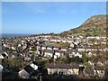
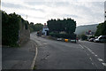
Cae America & Valley Road, Llanfairfechan
This photo was taken from near the golf course.
Image: © Ceri Thomas
Taken: Unknown
0.11 miles
8
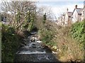
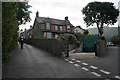
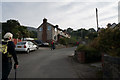
Afon Llanfairfechan
The upper town ascends the steep valley of the Afon Llanfairfechan with a road on each bank. Here, Nantyfelin Road crosses a bridge to reach Valley Road on the eastern bank. The riverbed is strewn with large, glacially-derived boulders and the sound of the rushing water fills the valley.
Image: © Jonathan Wilkins
Taken: 7 Mar 2014
0.13 miles