IMAGES TAKEN NEAR TO
Pendalar, LLANFAIRFECHAN, LL33 0RB
Introduction
This page details the photographs taken nearby to Pendalar, LL33 0RB by members of the Geograph project.
The Geograph project started in 2005 with the aim of publishing, organising and preserving representative images for every square kilometre of Great Britain, Ireland and the Isle of Man.

There are currently over 7.5m images from over14,400 individuals and you can help contribute to the project by visiting https://www.geograph.org.uk
Image Map
Images are licensed for reuse under creativecommons.org/licenses/by-sa/2.0
Notes
- Clicking on the map will re-center to the selected point.
- The higher the marker number, the further away the image location is from the centre of the postcode.
Image Listing (78 Images Found)
Images are licensed for reuse under creativecommons.org/licenses/by-sa/2.0
Image
Details
Distance
2
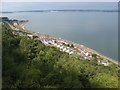
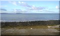
View of Pendalar
Looking down from the head of the tramway inclines to Pendalar. A verdant scene of Birch and Ash woodland covering the old screes of quarry waste. As it is high tide, there is no sign of the extensive Lavan Sands which extend most of the way to distant Anglesey.
Image: © Jonathan Wilkins
Taken: 8 Aug 2014
0.03 miles
4
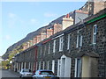
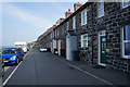
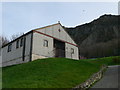
Mona Terrace
Built of local micro-diorite, the terrace maintains a strong sense of the local vernacular.
Image: © Ceri Thomas
Taken: 29 Sep 2012
0.05 miles