IMAGES TAKEN NEAR TO
Penmaenmawr Road, LLANFAIRFECHAN, LL33 0PH
Introduction
This page details the photographs taken nearby to Penmaenmawr Road, LL33 0PH by members of the Geograph project.
The Geograph project started in 2005 with the aim of publishing, organising and preserving representative images for every square kilometre of Great Britain, Ireland and the Isle of Man.

There are currently over 7.5m images from over14,400 individuals and you can help contribute to the project by visiting https://www.geograph.org.uk
Image Map (Loading...)


Getting Data...Please wait
Leaflet Map data © OpenStreetMap
Images are licensed for reuse under creativecommons.org/licenses/by-sa/2.0
Notes
- Clicking on the map will re-center to the selected point.
- The higher the marker number, the further away the image location is from the centre of the postcode.
Image Listing (73 Images Found)
Images are licensed for reuse under creativecommons.org/licenses/by-sa/2.0
Image
Details
Distance
1
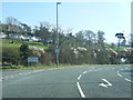
Penmaenmawr Road at Llanfairfechan boundary
Image: © Colin Pyle
Taken: 29 Mar 2019
0.02 miles
2
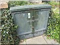
PO Cross Connection Cabinet on Penmaemawr Road, Llanfairfechan
http://www.ringbell.co.uk/nostalgia/aar.htm
See also: Image
Image: © Meirion
Taken: 6 Sep 2019
0.05 miles
3

HiPoints information QR code at The Heath, Llanfairfechan
HistoryPoints.org brings local history to your mobile phone. Main website at http://historypoints.org
See also: Image
Image: © Meirion
Taken: 6 Sep 2019
0.05 miles
4
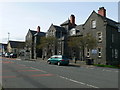
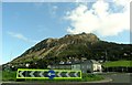
The Heath, Llanfairfechan
Conwy council offices on Penmaenmawr Road.
Image: © Eirian Evans
Taken: 6 Mar 2012
0.05 miles
5
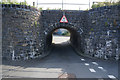
Very low bridge on Shore Road East, Llanfairfechan
Image: © Ian S
Taken: 17 Sep 2014
0.06 miles
7
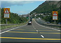
Eastbound along the A55
Approaching the roundabout in Llanfairfechan.
Image: © Mat Fascione
Taken: 29 Jun 2011
0.06 miles
8
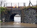
Railway Bridge, Llanfairfechan
Heavy rainfall cause localised flooding.
Image: © Chris Andrews
Taken: 14 Dec 2012
0.07 miles
9
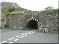
Railway bridge over Shore Road East, Llanfairfechan
Image: © Meirion
Taken: 3 Sep 2019
0.07 miles
10
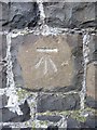
Benchmark on the Shore Road East Railway Bridge, Llanfairfechan
This benchmark is located on the railway bridge on Shore Road East in Llanfairfechan & it is shown in the current Ordnance Survey database at a height of 4.7823m above the Newlyn datum.
Image: © Meirion
Taken: 8 Nov 2010
0.07 miles