IMAGES TAKEN NEAR TO
Henryd, CONWY, LL32 8YD
Introduction
This page details the photographs taken nearby to LL32 8YD by members of the Geograph project.
The Geograph project started in 2005 with the aim of publishing, organising and preserving representative images for every square kilometre of Great Britain, Ireland and the Isle of Man.

There are currently over 7.5m images from over14,400 individuals and you can help contribute to the project by visiting https://www.geograph.org.uk
Image Map
Images are licensed for reuse under creativecommons.org/licenses/by-sa/2.0
Notes
- Clicking on the map will re-center to the selected point.
- The higher the marker number, the further away the image location is from the centre of the postcode.
Image Listing (9 Images Found)
Images are licensed for reuse under creativecommons.org/licenses/by-sa/2.0
Image
Details
Distance
2
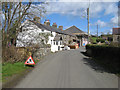
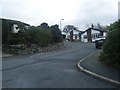
Pont Afon Gyffin
The main street of Henryd seen from the Rowen road, which crosses the Afon Gyffin just before the houses. The bridge is much disguised by ivy on one side, and appears to be a garden wall on the other. Since the name of the village translates as Old Ford, the bridge must be relatively modern!
Image: © Jonathan Wilkins
Taken: 5 Apr 2009
0.11 miles
7
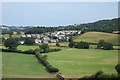
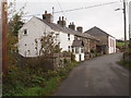
View to Henryd
View to Henryd from near Ty Newydd at grid reference SH 76795 74263.
Image: © Terry Hughes
Taken: 26 Jul 2006
0.23 miles
9
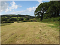
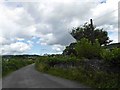
Henryd hay field
A view of this field which has recently had a hay or silage crop harvested from its outer parts. This summer scene is very typical of the lower part of the Conwy Valley, which is split by the hill at Baclaw.
Image: © Jonathan Wilkins
Taken: 12 Jul 2009
0.24 miles