IMAGES TAKEN NEAR TO
Pentywyn Road, CONWY, LL31 9YP
Introduction
This page details the photographs taken nearby to Pentywyn Road, LL31 9YP by members of the Geograph project.
The Geograph project started in 2005 with the aim of publishing, organising and preserving representative images for every square kilometre of Great Britain, Ireland and the Isle of Man.

There are currently over 7.5m images from over14,400 individuals and you can help contribute to the project by visiting https://www.geograph.org.uk
Image Map
Images are licensed for reuse under creativecommons.org/licenses/by-sa/2.0
Notes
- Clicking on the map will re-center to the selected point.
- The higher the marker number, the further away the image location is from the centre of the postcode.
Image Listing (45 Images Found)
Images are licensed for reuse under creativecommons.org/licenses/by-sa/2.0
Image
Details
Distance
1

Bwlch Farm
No longer an active farm but a very secluded static caravan park.
Image: © Jonathan Wilkins
Taken: 22 Oct 2008
0.09 miles
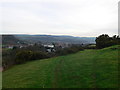
2
View east from above Bwlch Farm Caravan Park
The dark roofs of the caravans merge into the background. The outskirts of Llandudno Junction to the right.
Image: © Eirian Evans
Taken: 28 Jan 2012
0.10 miles
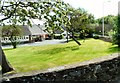
3
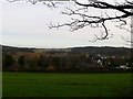
Recreation ground in Tywyn
Looking towards the Conwy valley in evening light.
Image: © Bill Boaden
Taken: 17 Feb 2017
0.11 miles
4
Bryn Tirion Farm
An original farm building of some antiquity, and wearing its years well. See also Image
Image: © Jonathan Wilkins
Taken: 19 Jul 2020
0.11 miles
5
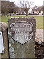
Old water valve marker on Pentywyn Road, Llandudno Junction
C.C.WATER
Image: © Meirion
Taken: 11 Mar 2020
0.12 miles
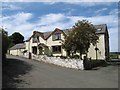
6

Bryn Tirion Farm
A very pretty remnant of the original rural, farming aspect of the Llanrhos district.
Image: © Jonathan Wilkins
Taken: 22 Oct 2008
0.12 miles
7
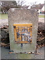
Hydrant marker on Pentywyn Road, Llandudno Junction
Image: © Meirion
Taken: 11 Mar 2020
0.12 miles
8
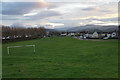
View south from Vardre
Over to Llandudno Junction and beyond to the foothills of Snowdonia.
Image: © Eirian Evans
Taken: 28 Jan 2012
0.12 miles
9

The new High Pastures
A development of new housing on part of the grounds of the High Pastures nursing home. Exclusive, luxury living is on offer - shame about the drains.
Image: © Jonathan Wilkins
Taken: 22 Oct 2008
0.13 miles
10
Junction of Marl Lane and Pentywyn Road
The bungalows are off Albert Drive. The shape of the trees indicates the direction of the prevailing winds.
Image: © Gerald England
Taken: 10 Jul 2014
0.13 miles