IMAGES TAKEN NEAR TO
Pendorlan Road, LLANDUDNO, LL30 3PS
Introduction
This page details the photographs taken nearby to Pendorlan Road, LL30 3PS by members of the Geograph project.
The Geograph project started in 2005 with the aim of publishing, organising and preserving representative images for every square kilometre of Great Britain, Ireland and the Isle of Man.

There are currently over 7.5m images from over14,400 individuals and you can help contribute to the project by visiting https://www.geograph.org.uk
Image Map
Images are licensed for reuse under creativecommons.org/licenses/by-sa/2.0
Notes
- Clicking on the map will re-center to the selected point.
- The higher the marker number, the further away the image location is from the centre of the postcode.
Image Listing (70 Images Found)
Images are licensed for reuse under creativecommons.org/licenses/by-sa/2.0
Image
Details
Distance
2
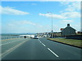
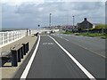
Glan-y-Mor Road at Maes Gwyn Road
At the west end of Penrhyn Bay. This was the line of the former Llandudno and Colwyn Bay Electric Railway, the tramway between those towns. The cycle lane is part of National Cycle Route 5 and the promenade forms part of the North Wales Coastal Path.
Image: © Alan Murray-Rust
Taken: 22 Jun 2024
0.07 miles
3
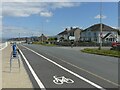
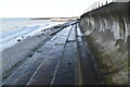
The promenade, Penrhyn Bay
National Cycle Route 5 joins the pedestrian way along this section, which also forms part of the North Wales Coastal Path.
The promenade was created by the Llandudno and Colwyn Bay Electric Railway to carry their tramway and was a private toll road. Damage caused during storms in the early 1950s was a factor in the demise of the tramway. The sea defences, which as can be seen are significantly higher than the roadway, only appeared much later.
Image: © Alan Murray-Rust
Taken: 22 Jun 2024
0.07 miles
4
Bae Penrhyn
Penrhyn Bay on a clear December day looking towards the Little Orme
Image: © Dot Potter
Taken: 27 Dec 2005
0.07 miles
5
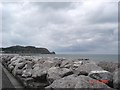
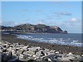
Bae Penrhyn
Looking across the manmade sea defences towards the Little Orme from Penrhyn Bay.
Image: © Dot Potter
Taken: 13 Aug 2005
0.07 miles
6
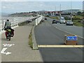
National Cycle Route 5, Penrhyn Bay
Beside Glan-Y-Mor Road.
Image: © JThomas
Taken: 15 Apr 2024
0.07 miles
8
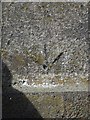
Rivet benchmark on Sea wall, Penrhyn Bay
This rivet benchmark is located on the sea wall on the NE side of the Glan-y-môr Road in Penrhyn Bay & it is shown in the current Ordnance Survey database at a height of 9.3921m above the Newlyn datum.
Image: © Meirion
Taken: 24 Feb 2011
0.07 miles
9
The Little Orme and Penrhyn Bay
Taken from the coastal path on Glan-y-Mor Road looking towards the Little Orme.
Image: © Jeff Buck
Taken: 26 Jul 2012
0.08 miles
10

Penrhyn Bay
Moon risen and daylight fading.
Image: © David Bremner
Taken: 5 Nov 2022
0.08 miles