IMAGES TAKEN NEAR TO
Cwlach Road, LLANDUDNO, LL30 2HS
Introduction
This page details the photographs taken nearby to Cwlach Road, LL30 2HS by members of the Geograph project.
The Geograph project started in 2005 with the aim of publishing, organising and preserving representative images for every square kilometre of Great Britain, Ireland and the Isle of Man.

There are currently over 7.5m images from over14,400 individuals and you can help contribute to the project by visiting https://www.geograph.org.uk
Image Map
Images are licensed for reuse under creativecommons.org/licenses/by-sa/2.0
Notes
- Clicking on the map will re-center to the selected point.
- The higher the marker number, the further away the image location is from the centre of the postcode.
Image Listing (461 Images Found)
Images are licensed for reuse under creativecommons.org/licenses/by-sa/2.0
Image
Details
Distance
1

Agapanthus and Callistemon against a blue sky
Overhanging Cwllach Road.
Callistemon otherwise known as the bottlebrush plant.
In Image]
Image: © Richard Hoare
Taken: 23 Jul 2019
0.02 miles
3
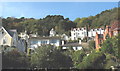
Villas above Church Walks
Many of these villas were built as holiday homes by Victorian mill owners and other entrepreneurs from the North of England.
Image: © Eric Jones
Taken: 20 Oct 2007
0.02 miles
4
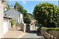
View down Cwllach Road
On a hot summer's day.
The Image] can be seen further down the road on the left.
Image: © Richard Hoare
Taken: 23 Jul 2019
0.03 miles
6
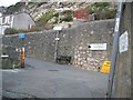
The Top of Ty'n y Maes Hill
At the top of the hill is Cwlach Street, which passes across the photo, and then Cwlach Road, which is higher up and to the left. Cwlach Road leads to Haulfre Gardens and is a no through road, wheareas Cwlach Street is a through road. On the right hand side on the wall is a sign warning of the dangers of cycling down the hill. For a close up of the sign see Image Also see Image for a view of the hill from the bottom.
Image: © John S Turner
Taken: 15 Feb 2007
0.04 miles
7
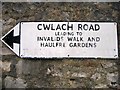
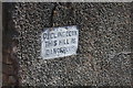
Old Road Sign
This old road sign, which somehow has escaped the modernising 'broom', is attached to the wall at the top of Ty'n y Maes Hill and can be seen in Image 'Parking Prohibited' has been painted out, but the road is still very narrow so parking is not advisable.
Image: © John S Turner
Taken: 15 Feb 2007
0.04 miles
8
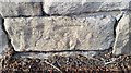
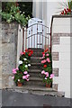
Ordnance Survey Cut Mark
This OS cut mark can be found on the wall NW side of Cwlach Road. It marks a point 40.178m above mean sea level.
Image: © Adrian Dust
Taken: 10 Oct 2017
0.04 miles
9
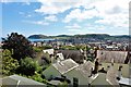
Across the rooftops towards the Little Orme
On a very hot summer's day.
Image: © Richard Hoare
Taken: 23 Jul 2019
0.04 miles
10

Male Silver-studded Blue (Plebeius argus), Great Orme
This butterfly is mainly found on heathland in southern England, with a few small populations on limestone in North Wales.
Image: © Mike Pennington
Taken: 19 Jul 1983
0.04 miles