IMAGES TAKEN NEAR TO
Grange Road, LLANDUDNO, LL30 1SN
Introduction
This page details the photographs taken nearby to Grange Road, LL30 1SN by members of the Geograph project.
The Geograph project started in 2005 with the aim of publishing, organising and preserving representative images for every square kilometre of Great Britain, Ireland and the Isle of Man.

There are currently over 7.5m images from over14,400 individuals and you can help contribute to the project by visiting https://www.geograph.org.uk
Image Map
Images are licensed for reuse under creativecommons.org/licenses/by-sa/2.0
Notes
- Clicking on the map will re-center to the selected point.
- The higher the marker number, the further away the image location is from the centre of the postcode.
Image Listing (50 Images Found)
Images are licensed for reuse under creativecommons.org/licenses/by-sa/2.0
Image
Details
Distance

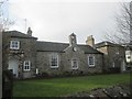
2
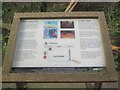
Information board at St. Mary's Well / Ffynnon Santes Fair, Llanrhos
Image: © Meirion
Taken: 11 Mar 2020
0.10 miles
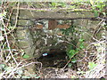
3
St Mary's Well / Ffynnon Santes Fair, Llanrhos
Dedicated to St Mary this holy well can be found at the side of a footpath in Llanrhos.
The well had been lost and covered up until 1993 when flash floods in the area caused widespread damage. It was rediscovered during the clearing up operation.
The nearby church of St Hilary's was originally dedicated to St Mary and is believed to have a close association with the well.
The well is just off the public footpath through a wooden gate. There is an information sign on site.
Image: © Meirion
Taken: 11 Mar 2020
0.10 miles
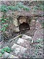
4
Ffynnon Santes Fair, Llanrhos
This old well was rediscovered by Ken Davies in January 1994, follow this link for more information http://people.bath.ac.uk/liskmj/living-spring/sourcearchive/ns2/ns2kd1.htm
Image: © BrianPritchard
Taken: 3 May 2008
0.15 miles
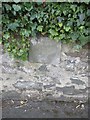
6
Possible boundary stone on Conway Road, Llanrhos
Simply marked as 'stone' on old maps of the area.
Image: © Meirion
Taken: 11 Mar 2020
0.17 miles
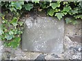
7
Old Boundary Marker
Parish Boundary Marker set in stone wall on the west side of the B5115 Conway Road, south of a school. Conwy community. No inscription.
Milestone Society National ID: CAE_CONWY01pb
Image: © M P Roberts
Taken: 13 Mar 2020
0.17 miles
8
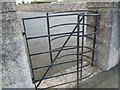
Kissing gate at the old school building, Llanrhos
Image: © Meirion
Taken: 11 Mar 2020
0.17 miles
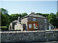
9
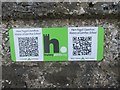
HiPoints information QR code for the old school, Llanrhos
HistoryPoints.org brings local history to your mobile phone. Main website at https://historypoints.org
See also: Image
Image: © Meirion
Taken: 11 Mar 2020
0.17 miles