IMAGES TAKEN NEAR TO
LLANDUDNO, LL30 1LB
Introduction
This page details the photographs taken nearby to LL30 1LB by members of the Geograph project.
The Geograph project started in 2005 with the aim of publishing, organising and preserving representative images for every square kilometre of Great Britain, Ireland and the Isle of Man.

There are currently over 7.5m images from over14,400 individuals and you can help contribute to the project by visiting https://www.geograph.org.uk
Image Map
Images are licensed for reuse under creativecommons.org/licenses/by-sa/2.0
Notes
- Clicking on the map will re-center to the selected point.
- The higher the marker number, the further away the image location is from the centre of the postcode.
Image Listing (19 Images Found)
Images are licensed for reuse under creativecommons.org/licenses/by-sa/2.0
Image
Details
Distance
1
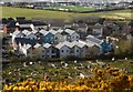
Tan y Fron
Tan y Fron is an extra-care centre.
Image: © Ceri Thomas
Taken: 29 Apr 2015
0.06 miles
3
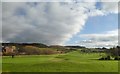
Maesdu Golf Club
Most of the course is on the other side of the road nearer to the sea, but the clubhouse is to the left. The other building to the right is part of Llandudno General Hospital.
Image: © Bill Boaden
Taken: 17 Feb 2017
0.11 miles
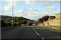
4
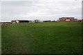
Maesdu with pylon
A surprisingly massive pylon takes the strain of transmission lines where they change direction towards the hospital. The distant view of green spaces is entirely recreational, with Maesdu Golf Course nearest. In the distance is the North Wales Golf Links and in town to the right is the Oval, home of the Llandudno Cricket Club. The dark mass of the Great Orme lies beyond the limits of the town.
Image: © Jonathan Wilkins
Taken: 31 Oct 2020
0.13 miles
5
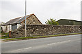
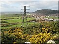
North Wales WWII defences: Deganwy - loopholed wall (1)
-
Loopholed wall: DoB ID: S0015613
Located along the A546 at Deganwy, the wall faces west, and incorporates a pair of loopholes overlooking the open ground between the sea and the road now occupied by a golf course.
Image
Image: © Mike Searle
Taken: 10 May 2016
0.16 miles
6
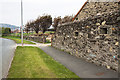
North Wales WWII defences: Deganwy - loopholed wall (2)
-
Loopholed wall: DoB ID: S0015613
Located along the A546 at Deganwy, the wall faces west, and incorporates a pair of loopholes overlooking the open ground between the sea and the road now occupied by a golf course.
Image
Image: © Mike Searle
Taken: 10 May 2016
0.16 miles
7
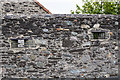
North Wales WWII defences: Deganwy - loopholed wall (3)
-
Loopholed wall: DoB ID: S0015613
Located along the A546 at Deganwy, the wall faces west, and incorporates a pair of loopholes overlooking the open ground between the sea and the road now occupied by a golf course.
Image
Image: © Mike Searle
Taken: 10 May 2016
0.16 miles
8
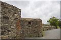
North Wales WWII defences: Deganwy - loopholed wall (4)
-
Loopholed wall: DoB ID: S0015612
Further along at the end of the wall, a further section of it projects out at an angle having a loophole that faces north west.
Image
Image: © Mike Searle
Taken: 10 May 2016
0.17 miles
10
Former cottage hospital Llandudno
In fact an annex to the nearby Llandudno Hospital, it now houses the Memory Clinic, Breast Test Wales and the Aggression unit.
Image: © Richard Hoare
Taken: 28 Apr 2017
0.17 miles