IMAGES TAKEN NEAR TO
Maesdu Place, LLANDUDNO, LL30 1HT
Introduction
This page details the photographs taken nearby to Maesdu Place, LL30 1HT by members of the Geograph project.
The Geograph project started in 2005 with the aim of publishing, organising and preserving representative images for every square kilometre of Great Britain, Ireland and the Isle of Man.

There are currently over 7.5m images from over14,400 individuals and you can help contribute to the project by visiting https://www.geograph.org.uk
Image Map
Images are licensed for reuse under creativecommons.org/licenses/by-sa/2.0
Notes
- Clicking on the map will re-center to the selected point.
- The higher the marker number, the further away the image location is from the centre of the postcode.
Image Listing (28 Images Found)
Images are licensed for reuse under creativecommons.org/licenses/by-sa/2.0
Image
Details
Distance
1
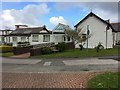
Former cottage hospital Llandudno
In fact an annex to the nearby Llandudno Hospital, it now houses the Memory Clinic, Breast Test Wales and the Aggression unit.
Image: © Richard Hoare
Taken: 28 Apr 2017
0.02 miles
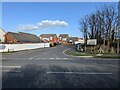
3

Roundabout on Bryniau Road
Not the principal route, but still a main road into Llandudno, seen here at its junction with Maesdu Road. It has to cross the railway just over the roundabout.
Image: © Bill Boaden
Taken: 17 Feb 2017
0.09 miles
4

Ordnance Survey Cut Mark
This OS cut mark can be found on Railway Cottage. It marks a point 4.729m above mean sea level.
Image: © Adrian Dust
Taken: 27 Mar 2023
0.11 miles
5
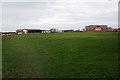
Maesdu Golf Club
Most of the course is on the other side of the road nearer to the sea, but the clubhouse is to the left. The other building to the right is part of Llandudno General Hospital.
Image: © Bill Boaden
Taken: 17 Feb 2017
0.11 miles

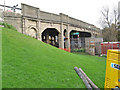
7

Railway north from Bryniau Road
The twin track branch line between Llandudno Junction and the town itself.
Image: © Stephen Craven
Taken: 20 Jun 2024
0.12 miles
8
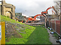
Gap in the road
Taken on the day after the demolition of the bridge imaged from a similar position just three days previously Image The machines are operating on a wooden deck laid over the two railway tracks, and are removing the outer parts of the bridge structure as far back as the embankment abutments. The temporary, replacement footbridge structure can be seen in the background.
Image: © Jonathan Wilkins
Taken: 16 Nov 2009
0.12 miles
9
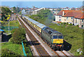
Railway at Llandudno
Train departing Llandudno.
Image: © Wayland Smith
Taken: 4 May 2019
0.13 miles
10
Maesdu Bridge
This concrete structure spanning the railway to Llandudno has been a source of concern for many years. Built in concrete, structural deterioration advanced so far that it was necessary to install a set of girders beneath the central span to support the road deck. A weight limit of 7.5 tonnes has been in force since that time. This image was captured days before the demolition was scheduled, and plant and security fencing can be seen in place.
Image: © Jonathan Wilkins
Taken: 13 Nov 2009
0.13 miles