IMAGES TAKEN NEAR TO
Eglwysbach, COLWYN BAY, LL28 5SE
Introduction
This page details the photographs taken nearby to LL28 5SE by members of the Geograph project.
The Geograph project started in 2005 with the aim of publishing, organising and preserving representative images for every square kilometre of Great Britain, Ireland and the Isle of Man.

There are currently over 7.5m images from over14,400 individuals and you can help contribute to the project by visiting https://www.geograph.org.uk
Image Map
Images are licensed for reuse under creativecommons.org/licenses/by-sa/2.0
Notes
- Clicking on the map will re-center to the selected point.
- The higher the marker number, the further away the image location is from the centre of the postcode.
Image Listing (5 Images Found)
Images are licensed for reuse under creativecommons.org/licenses/by-sa/2.0
Image
Details
Distance
1
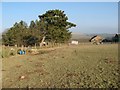
Llindir with copse
A small copse of conifers makes a shelter for the farmhouse at Llindir.
Image: © Jonathan Wilkins
Taken: 26 Jan 2017
0.02 miles
2
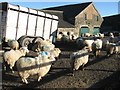
Farmyard with sheep, Llindir
Ewses have been gathered in the farmyard at Llindir.
Image: © Jonathan Wilkins
Taken: 25 Jan 2017
0.02 miles
3
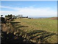
View to Llindir
Looking along the roadside towards the isolated, hilltop farm.
Image: © Jonathan Wilkins
Taken: 25 Jan 2017
0.02 miles
4
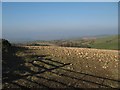
Eaten-down beets
A field adjacent to the farm appears to be covered in small rocks, but they are actually beets with their green tops and upper parts nibbled off by the sheep.
Image: © Jonathan Wilkins
Taken: 26 Jan 2017
0.07 miles
5
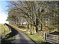
Roadside woodland
Winter is a great time to see trees, as here in a small woodland by the road to Llindir.
Image: © Jonathan Wilkins
Taken: 25 Jan 2017
0.17 miles