IMAGES TAKEN NEAR TO
Glan Conwy, COLWYN BAY, LL28 5PL
Introduction
This page details the photographs taken nearby to LL28 5PL by members of the Geograph project.
The Geograph project started in 2005 with the aim of publishing, organising and preserving representative images for every square kilometre of Great Britain, Ireland and the Isle of Man.

There are currently over 7.5m images from over14,400 individuals and you can help contribute to the project by visiting https://www.geograph.org.uk
Image Map
Images are licensed for reuse under creativecommons.org/licenses/by-sa/2.0
Notes
- Clicking on the map will re-center to the selected point.
- The higher the marker number, the further away the image location is from the centre of the postcode.
Image Listing (6 Images Found)
Images are licensed for reuse under creativecommons.org/licenses/by-sa/2.0
Image
Details
Distance
1
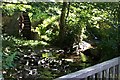
Waterwheel and falls
An old waterwheel and falls at SH 81527 74598 taken from the roadbridge.
Image: © Terry Hughes
Taken: 14 Jul 2006
0.06 miles
2
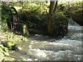
Rhod Ddwr ar Nant-y-Garreg Ddu / Waterwheel on Nant-y-Garreg Ddu
Image: © Ceri Thomas
Taken: 30 Oct 2021
0.08 miles
3
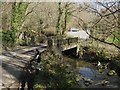
Bridge, Nant y Gareg-ddu
The minor road drops very steeply into the wooded valley to cross the stream.
Image: © Jonathan Wilkins
Taken: 12 Mar 2014
0.08 miles
4
Coed ger Nant-y-Garreg Ddu / Woodland near Nant-y-Garreg Ddu
Image: © Ceri Thomas
Taken: 30 Oct 2021
0.10 miles
5
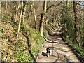
Track to Cymerau
A track leads along the valley, with steep, wooded slopes falling steeply to the stream. No sign of the nearby footpath can be discerned.
Image: © Jonathan Wilkins
Taken: 12 Mar 2014
0.12 miles
6
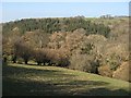
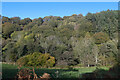
Coed Bwlch-y-wern-hir
A view over sheep pasture to the wooded valley of Bwlch-y-wern-hir. Deciduous trees make a wonderful scene before the leaves break in Spring, and a contrast against the conifer plantation below the road to Penrhiw Uchaf.
Image: © Jonathan Wilkins
Taken: 12 Mar 2014
0.22 miles