IMAGES TAKEN NEAR TO
Bryn-y-Maen, COLWYN BAY, LL28 5ES
Introduction
This page details the photographs taken nearby to LL28 5ES by members of the Geograph project.
The Geograph project started in 2005 with the aim of publishing, organising and preserving representative images for every square kilometre of Great Britain, Ireland and the Isle of Man.

There are currently over 7.5m images from over14,400 individuals and you can help contribute to the project by visiting https://www.geograph.org.uk
Image Map
Images are licensed for reuse under creativecommons.org/licenses/by-sa/2.0
Notes
- Clicking on the map will re-center to the selected point.
- The higher the marker number, the further away the image location is from the centre of the postcode.
Image Listing (4 Images Found)
Images are licensed for reuse under creativecommons.org/licenses/by-sa/2.0
Image
Details
Distance
1
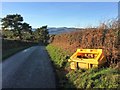
I'm no prude but I think that is topless!
Still some traces of snow on the Carneddau.
Image: © Richard Hoare
Taken: 23 Dec 2017
0.06 miles
2
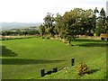
Caravan field
A Caravan Club field site adjacent to Ffrith Wen with excellent views of the lower Conwy Valley, which is today obscured by a hazy mist.
Image: © Jonathan Wilkins
Taken: 20 Oct 2015
0.08 miles
3
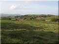
Rocky knoll
Pasture below Ffrith Wen surrounds a couple of rocky knolls, beyond which the ground drops steeply to Tynllwyn. The rock outcrops are mudstones of the Elwy Formation (Silurian). Elsewhere the ground is mantled by glacial deposits, and it is a matter of interest that a large glacial erratic boulder has been dragged from the field to an out-of-the-way spot where rock has been quarried for local purposes.
Image: © Jonathan Wilkins
Taken: 20 Oct 2015
0.14 miles
4
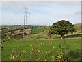
Power transmission line
The power transmission line to Mochdre runs across the valley here, highlighting what a secluded spot Tynllwyn Farm occupies. Twigs from the hedge intrude a bit, but this is a very difficult square, with deeply-incised lanes and thick hedges!
Image: © Jonathan Wilkins
Taken: 20 Oct 2015
0.14 miles