IMAGES TAKEN NEAR TO
Glan-y-Wern Road, COLWYN BAY, LL28 5BS
Introduction
This page details the photographs taken nearby to Glan-y-Wern Road, LL28 5BS by members of the Geograph project.
The Geograph project started in 2005 with the aim of publishing, organising and preserving representative images for every square kilometre of Great Britain, Ireland and the Isle of Man.

There are currently over 7.5m images from over14,400 individuals and you can help contribute to the project by visiting https://www.geograph.org.uk
Image Map
Images are licensed for reuse under creativecommons.org/licenses/by-sa/2.0
Notes
- Clicking on the map will re-center to the selected point.
- The higher the marker number, the further away the image location is from the centre of the postcode.
Image Listing (17 Images Found)
Images are licensed for reuse under creativecommons.org/licenses/by-sa/2.0
Image
Details
Distance
1
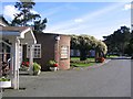
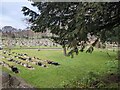
Crematorium
This Crematorium is at SH 827 794. Near the village of Mochdre, Colwyn Bay.
Image: © Dave Smethurst
Taken: 20 Sep 2005
0.07 miles
2
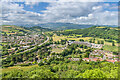
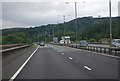
From Bryn Euryn
Looking southwest from below the top of Bryn Euryn, with the A55 North Wales Expressway snaking across the photo en route to Conway and the mountains of Eryri/Snowdonia in the background. On the left of the road is the village of Mochdre with the large former Quinton Hazell factory, a large automotive accessories manufacturer which operated here until closure in 2012. The site is now a business park, Quinton Hazell Enterprise Park.
Image: © Ian Capper
Taken: 22 Jun 2024
0.11 miles

4

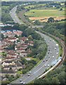
View south-west from Bryn Euryn
Including the A55 trunk road, Bron-y-Nant cemetery (associated with a former isolation hospital) and Quinton Hazell Enterprise Park. The Conwy estuary is visible in the distance.
Image: © Stephen Craven
Taken: 22 Jun 2024
0.13 miles
5

Farmland by the Afon Ganol
Pasture land leading down to the Afon Ganol. This remarkable gap in the hills is the result of glacial melt-water spilling out to the sea from the blocked Conwy drainage during the last ice age. Nowadays the drainage is reversed and runs into the Conwy estuary near to Glan Conwy. Dinerth Road and adjacent estates are seen in the background.
Image: © Jonathan Wilkins
Taken: 2 May 2020
0.15 miles
6
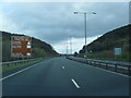
Dwy ffordd i fynd heibio Mochdre / Two ways around Mochdre
The A55 dominates the landscape to such a degree that I did not notice the steam train (Earl of Mount Edgcumbe?) until I downloaded the image.
Image: © Ceri Thomas
Taken: 20 Aug 2012
0.15 miles
8
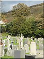
Room for expansion?
The cemetery is beginning to fill up.
Image: © David Medcalf
Taken: 8 Mar 2022
0.16 miles
10
Gravestones and a seagull at Colwyn Bay Crematorium
Image: © Jeff Tomlinson
Taken: 27 Oct 2017
0.17 miles