IMAGES TAKEN NEAR TO
TREFRIW, LL27 0JW
Introduction
This page details the photographs taken nearby to LL27 0JW by members of the Geograph project.
The Geograph project started in 2005 with the aim of publishing, organising and preserving representative images for every square kilometre of Great Britain, Ireland and the Isle of Man.

There are currently over 7.5m images from over14,400 individuals and you can help contribute to the project by visiting https://www.geograph.org.uk
Image Map
Images are licensed for reuse under creativecommons.org/licenses/by-sa/2.0
Notes
- Clicking on the map will re-center to the selected point.
- The higher the marker number, the further away the image location is from the centre of the postcode.
Image Listing (45 Images Found)
Images are licensed for reuse under creativecommons.org/licenses/by-sa/2.0
Image
Details
Distance
1
Flood bank
The village of Trefriw is protected from flooding by the capricious Afon Conwy behind this tall bank, in addition to the one at the riverside. Here, floodwaters are held between the two banks. The distant building is the Prince's Arms Hotel.
Image: © Jonathan Wilkins
Taken: 5 Oct 2008
0.05 miles
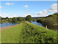
2
Flood bank near the Afon Conwy
The western floodbank runs at the side of the old course of the Afon Crafnant at this point. A low-lying field occupies the space between the Afon Conwy floodbank and this one, and the river can be seen to the North.
Image: © Jonathan Wilkins
Taken: 7 Dec 2008
0.08 miles
3
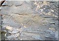
Ordnance Survey Cut Mark
This OS cut mark can be found on the SE angle of Arosfa. It marks a point 8.264m above mean sea level.
Image: © Adrian Dust
Taken: 27 Oct 2018
0.08 miles
4
River Conwy near Trefriw
In the centre is the Princes Arms Hotel.
Image: © Eirian Evans
Taken: 2 Nov 2010
0.08 miles
5
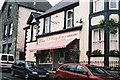
Butcher's shop Trefriw
Arguably the best tasting lamb in the Conwy Valley.
Image: © Ron Galliers
Taken: 21 Mar 2009
0.11 miles
6
Afon Crafnant
Flooding in the Conwy valley is an ever-present risk, so the Afon Crafnant is constrained between high banks at this point. Footpaths run along all of the banks here, making an interesting circuit from the village. A mat of floating debris has been blown to one end of the field flooded by an overnight downpour.
Image: © Jonathan Wilkins
Taken: 5 Oct 2008
0.11 miles
7
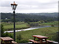
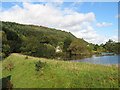
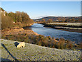
The curve of the Conwy
Taken from outside the Princes Arms Hotel (once the Belle Vue Hotel) looking upstream toward Trefriw and across the Conwy valley.
Image: © Karen Chantrey Wood
Taken: 28 Sep 2008
0.13 miles
9
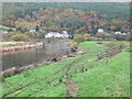
Site of Trefriw Quay
Rapids in the river here disguise the fact that it is tidal in this stretch. The left bank of the river by the trees in the distance is the site of the quays where boats would come up from Conwy for trade at high tide. In years past, pleasure boats would also make the journey. There was never sufficient water over these shoals for boats to travel any further upstream.
Image: © Jonathan Wilkins
Taken: 7 Dec 2008
0.14 miles
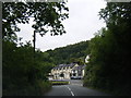
10
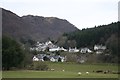
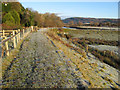
Trefriw from the Conwy embankment
Looking back towards the village, across the course of the Afon Crafnant, from the footpath along the Cob, the Conwy flood embankment.
Image: © Dave Dunford
Taken: 24 Feb 2013
0.14 miles