IMAGES TAKEN NEAR TO
Melin-y-Coed, LLANRWST, LL26 0SL
Introduction
This page details the photographs taken nearby to LL26 0SL by members of the Geograph project.
The Geograph project started in 2005 with the aim of publishing, organising and preserving representative images for every square kilometre of Great Britain, Ireland and the Isle of Man.

There are currently over 7.5m images from over14,400 individuals and you can help contribute to the project by visiting https://www.geograph.org.uk
Image Map
Images are licensed for reuse under creativecommons.org/licenses/by-sa/2.0
Notes
- Clicking on the map will re-center to the selected point.
- The higher the marker number, the further away the image location is from the centre of the postcode.
Image Listing (4 Images Found)
Images are licensed for reuse under creativecommons.org/licenses/by-sa/2.0
Image
Details
Distance
1
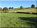
Landscape with sheep
An idyllic, dewy Autumn morning in the fields above Nant y Goron.
Image: © Jonathan Wilkins
Taken: 12 Oct 2014
0.18 miles
2
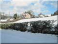
Road from Melin y Coed to Carmel from Bethel Melin y Coed
From near the rear of Bethel Chapel, Melin y Coed, looking towards the road which leads from the bridge near the chapel up to Carmel and the tops.
Image: © Rowena Evans
Taken: 27 Feb 2006
0.18 miles
3
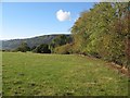
Fields near Bryndyffryn
Footpaths near here are not well marked or used, so we were forced to ad-lib and head for another route nearby. The mature trees of the hedgerow were a delight in the Autumn sunshine. In the distance are the dark, conifers of the Gwydir Forest.
Image: © Jonathan Wilkins
Taken: 12 Oct 2014
0.22 miles
4
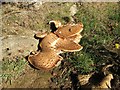
Scaly Polypore
A fine example of Polyporus squamosus growing on exposed roots at the edge of a hedgerow. An earlier, dead fruiting body is lying detached on the ground nearby.
Image: © Jonathan Wilkins
Taken: 12 Oct 2014
0.22 miles