IMAGES TAKEN NEAR TO
Pentrefoelas, BETWS-Y-COED, LL24 0HW
Introduction
This page details the photographs taken nearby to LL24 0HW by members of the Geograph project.
The Geograph project started in 2005 with the aim of publishing, organising and preserving representative images for every square kilometre of Great Britain, Ireland and the Isle of Man.

There are currently over 7.5m images from over14,400 individuals and you can help contribute to the project by visiting https://www.geograph.org.uk
Image Map
Images are licensed for reuse under creativecommons.org/licenses/by-sa/2.0
Notes
- Clicking on the map will re-center to the selected point.
- The higher the marker number, the further away the image location is from the centre of the postcode.
Image Listing (10 Images Found)
Images are licensed for reuse under creativecommons.org/licenses/by-sa/2.0
Image
Details
Distance
1
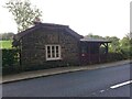
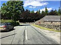
Toll House, A5, Hendre-isaf
On the South side of the road, labelled Hendre-isaf Gate (Lower Hendre) in 1900 maps. It served the Shrewsbury to Holyhead Turnpike Trust. There is a reference near the bridge on the other side of the house called Hendre-isaf to an "Old Gate" over the River Conway with an earlier bridge, which was by-passed in Thomas Telford's improvements of 1815-1820. This house dates from then.
Grade II Listed Building Cadwr Nᴼ. 18328 https://cadwpublic-api.azurewebsites.net/reports/listedbuilding/FullReport?lang=&id=18328 - British Listed Buildings - https://britishlistedbuildings.co.uk/300018328-tyr-peg-ysbyty-ifan#.ZAtKqB_P1PY
Milestone Society National ID: CON.PTF01
Image: © David Elis-Williams
Taken: 10 Mar 2023
0.00 miles
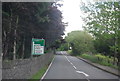
7
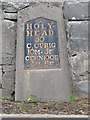
Old Milestone by the A5, Bro Garmon Parish
Telford Plate by the A5, in parish of Bro Garmon (Conwy County Borough District), South of Voelas.
Inscription reads:- : HOLY- / HEAD / 50 / C,CURIG / 10M-5F / CERNIOGE / 3M-6F :
Surveyed
Milestone Society National ID: DEN_HH50
Image: © Milestone Society
Taken: Unknown
0.21 miles
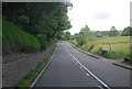
8
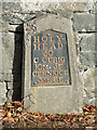
Old Milestone
Milestone on the A.5 near to Glan Conwy, Conwy for overall view see http://www.geograph.org.uk/photo/4304443
Image: © Keith Evans
Taken: 17 Oct 2014
0.21 miles
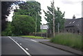
10
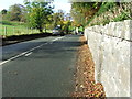
Holyhead 50
Milestone next to the wall on the A.5 near to Glan Conwy, Conwy for close up view see http://www.geograph.org.uk/photo/4304438
Image: © Keith Evans
Taken: 17 Oct 2014
0.24 miles