IMAGES TAKEN NEAR TO
Parc, BALA, LL23 7YU
Introduction
This page details the photographs taken nearby to LL23 7YU by members of the Geograph project.
The Geograph project started in 2005 with the aim of publishing, organising and preserving representative images for every square kilometre of Great Britain, Ireland and the Isle of Man.

There are currently over 7.5m images from over14,400 individuals and you can help contribute to the project by visiting https://www.geograph.org.uk
Image Map
Images are licensed for reuse under creativecommons.org/licenses/by-sa/2.0
Notes
- Clicking on the map will re-center to the selected point.
- The higher the marker number, the further away the image location is from the centre of the postcode.
Image Listing (1 Images Found)
Images are licensed for reuse under creativecommons.org/licenses/by-sa/2.0
Image
Details
Distance
1
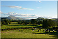
Fields south of Cyffdy
The fields lie to the south of Cyffdy, once a farm with a number of associated buildings which have been converted to holiday accommodation. More unusual accommodation is in the field in the foreground; the raised wooden structures appear to be duck houses!
Aran Benllyn is the obvious distant mountain.
Image: © Trevor Littlewood
Taken: 14 Sep 2013
0.10 miles