IMAGES TAKEN NEAR TO
Parc, BALA, LL23 7YP
Introduction
This page details the photographs taken nearby to LL23 7YP by members of the Geograph project.
The Geograph project started in 2005 with the aim of publishing, organising and preserving representative images for every square kilometre of Great Britain, Ireland and the Isle of Man.

There are currently over 7.5m images from over14,400 individuals and you can help contribute to the project by visiting https://www.geograph.org.uk
Image Map
Images are licensed for reuse under creativecommons.org/licenses/by-sa/2.0
Notes
- Clicking on the map will re-center to the selected point.
- The higher the marker number, the further away the image location is from the centre of the postcode.
Image Listing (6 Images Found)
Images are licensed for reuse under creativecommons.org/licenses/by-sa/2.0
Image
Details
Distance
1
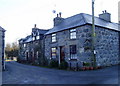
Houses in Parc
The three houses are, from right to left, Yr Hen Post, Ty Canol and Ty Pella - Old Postoffice, Middle House and Furthest House.
Image: © Eirian Evans
Taken: 3 Feb 2007
0.03 miles
2
Parc Village
Parc is named after the historical association as a hunting park. It is also the birth place of Merched y Wawr – the Welsh Women’s Institute established here in 1967.
Image: © Rick Crowley
Taken: 15 Apr 2011
0.03 miles
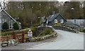
3
Stone-built house in Parc
Parc is a small settlement beside the Afon Llafar close to Bala. A bridge to the right side of the image carries pedestrians over the river.
Image: © Trevor Littlewood
Taken: 14 Sep 2013
0.06 miles
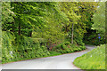
4
Parc, the road to Arenig
View north along the minor road to Arenig. Arenig used to be a village, but still has 6 houses, 2 bugalows and a disused chapel converted into a holiday home scattered along the side of the road. Locally it's still considered a village.
Image: © michael ely
Taken: 28 Apr 2006
0.09 miles
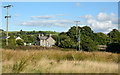
5
Parc
On the outskirts of this tiny village that straddles the Afon Llafar at the bottom of a steep descent.
Image: © michael ely
Taken: 28 Apr 2006
0.13 miles
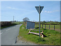
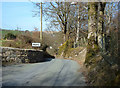
6
Approach to Parc from the south
Around the corner the road narrows and plunges very steeply down to the village. On the corner, a minor road branches west serving outlying farms and dwellings.
Image: © Nigel Brown
Taken: 27 May 2009
0.14 miles