IMAGES TAKEN NEAR TO
Llanfairtalhaiarn, ABERGELE, LL22 8TB
Introduction
This page details the photographs taken nearby to LL22 8TB by members of the Geograph project.
The Geograph project started in 2005 with the aim of publishing, organising and preserving representative images for every square kilometre of Great Britain, Ireland and the Isle of Man.

There are currently over 7.5m images from over14,400 individuals and you can help contribute to the project by visiting https://www.geograph.org.uk
Image Map
Images are licensed for reuse under creativecommons.org/licenses/by-sa/2.0
Notes
- Clicking on the map will re-center to the selected point.
- The higher the marker number, the further away the image location is from the centre of the postcode.
Image Listing (6 Images Found)
Images are licensed for reuse under creativecommons.org/licenses/by-sa/2.0
Image
Details
Distance
1
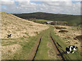
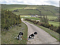
Track to Bedwyn
Continuing our descent, with the farm out-buildings by the public road in view.
Image: © Jonathan Wilkins
Taken: 19 Apr 2013
0.12 miles
2
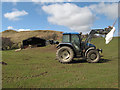
Nitrogen time
A fertiliser bag dangles from this tractor after hoisting into a spreader. Moel Unben with its bleached grass and dead bracken colours rises in the background. We were amused by the ewe who had taken a defensive posture on top of a heap of soil at the barn.
Image: © Jonathan Wilkins
Taken: 19 Apr 2013
0.14 miles
3
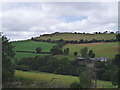
Moel Unben
There were lead mines on the western side of Moel Unben at one time. This view is the eastern side, with an abandoned farm on its slopes.
Image: © Eirian Evans
Taken: 7 Aug 2006
0.20 miles
4
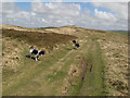
Track on Moel Unben
The way down from the summit was along the access track which curves round the southern slope of the common land. My assistants were very pleased that the sheep had stayed at the north end where the grass was better.
Image: © Jonathan Wilkins
Taken: 19 Apr 2013
0.21 miles
5
Track and Bedwyn Isaf
A well-maintained concrete road leading to Bedwyn Isaf carries a public footpath. On the horizon in the right of the image is Pen y Mwdwl (Image). The translation of 'mwdwl' as 'haycock' does not seem very apt from this direction.
Image: © Jonathan Wilkins
Taken: 19 Apr 2013
0.23 miles
6
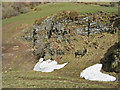
Quarry with snowdrift
It was a surprise to find a significant snowdrift in the gully that is formed by this old quarry. The rock that was exploited is a sandstone member of the Silurian Elwy Group.
Image: © Jonathan Wilkins
Taken: 19 Apr 2013
0.24 miles