IMAGES TAKEN NEAR TO
Trofarth, ABERGELE, LL22 8BW
Introduction
This page details the photographs taken nearby to LL22 8BW by members of the Geograph project.
The Geograph project started in 2005 with the aim of publishing, organising and preserving representative images for every square kilometre of Great Britain, Ireland and the Isle of Man.

There are currently over 7.5m images from over14,400 individuals and you can help contribute to the project by visiting https://www.geograph.org.uk
Image Map (Loading...)


Getting Data...Please wait
Leaflet Map data © OpenStreetMap
Images are licensed for reuse under creativecommons.org/licenses/by-sa/2.0
Notes
- Clicking on the map will re-center to the selected point.
- The higher the marker number, the further away the image location is from the centre of the postcode.
Image Listing (5 Images Found)
Images are licensed for reuse under creativecommons.org/licenses/by-sa/2.0
Image
Details
Distance
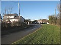
1
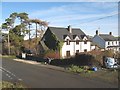
Capel Nebo houses
A modern house has replaced Capel Nebo, although the porch carries a stone reading "Capel Nebo, 188" in memory. It is notable that some editions of the digital map (e.g. 1:50,000) still show a place of worship here. I am told by a local resident that the adjacent, older house once operated as a post office.
Image: © Jonathan Wilkins
Taken: 10 Jan 2018
0.02 miles
2
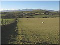
Capel Nebo footpath
Not signed on the ground, and not much used, but offering a fine view across the dingle to Capel Nebo and ultimately the summits of the Carneddau, still hanging onto a bit of snow.
Image: © Jonathan Wilkins
Taken: 10 Jan 2018
0.02 miles
3
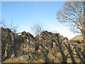
Bron-y-nant ruin
The remains of a farmstead given as Bron-y-nant on larger scale maps. Apparently, the original Capel Nebo was down here before its rebuilding in 1888 at the road junction (see Image).
Image: © Jonathan Wilkins
Taken: 10 Jan 2018
0.11 miles
4
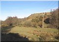
Valley bottom
The valley below Fron Gynnen.
Image: © Jonathan Wilkins
Taken: 10 Jan 2018
0.15 miles
5
Rhandir garage
Dwelling and commercial property at Rhandir.
Image: © Jonathan Wilkins
Taken: 10 Jan 2018
0.16 miles