IMAGES TAKEN NEAR TO
Trofarth, ABERGELE, LL22 8BS
Introduction
This page details the photographs taken nearby to LL22 8BS by members of the Geograph project.
The Geograph project started in 2005 with the aim of publishing, organising and preserving representative images for every square kilometre of Great Britain, Ireland and the Isle of Man.

There are currently over 7.5m images from over14,400 individuals and you can help contribute to the project by visiting https://www.geograph.org.uk
Image Map
Images are licensed for reuse under creativecommons.org/licenses/by-sa/2.0
Notes
- Clicking on the map will re-center to the selected point.
- The higher the marker number, the further away the image location is from the centre of the postcode.
Image Listing (11 Images Found)
Images are licensed for reuse under creativecommons.org/licenses/by-sa/2.0
Image
Details
Distance
1
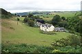
Gofer farm near Trofarth above Colwyn Bay
Gofer farm lies just over a kilometre Northwest of Trofarth above Colwyn Bay at grid reference SH 84112 72625.
Image: © Terry Hughes
Taken: 12 Aug 2006
0.01 miles
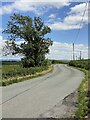
2
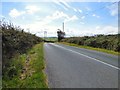
The B5113
The high road from Colwyn Bay to Pentrefoelas approaching Chweffordd.
Image: © Gerald England
Taken: 16 Sep 2015
0.16 miles
4
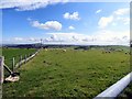
View from B5113
The Clwydian Hills are in the far distance.
Image: © Richard Hoare
Taken: 16 Sep 2015
0.18 miles
5
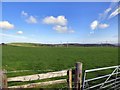
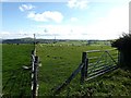
Cefn Du
Fields by the side of the B5113.
Image: © Gerald England
Taken: 16 Sep 2015
0.19 miles
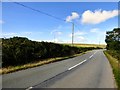
6
Overhead power supply lines
Note also the two wind turbines in the centre distance.
Image: © Alan Hughes
Taken: 22 Jun 2024
0.20 miles
7
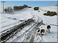
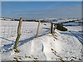
Footpath to Cefn Du
Vehicle tracks on the frozen way to the pastures of Cefn Du.
Image: © Jonathan Wilkins
Taken: 24 Jan 2013
0.21 miles
8
B5113 near Cefn Dhu
The high road to Colwyn Bay from Pentrefoelas near Cefn Du.
Image: © Gerald England
Taken: 16 Sep 2015
0.21 miles
9
Footpath to Chweffordd
Looking down the footpath and farm track that runs over Cefn Du, the upland pasture covered with snow. I am tempted to think that this track is the last of the six roads (Chweffordd = Chwech Ffyrdd?) that meet at this upland junction. On the distant horizon can be seen Moelfre Uchaf, a very prominent landmark.
Image: © Jonathan Wilkins
Taken: 24 Jan 2013
0.22 miles
10
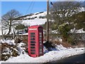
Telephone Call Box at Chweffordd, with Cefn Du in the Background
A view of a Telephone Call Box at Chweffordd, with the hill known as Cefn Du in the Background.
Image: © Stephen Elwyn RODDICK
Taken: 3 Mar 2006
0.24 miles