IMAGES TAKEN NEAR TO
Mor Awel, ABERGELE, LL22 7ND
Introduction
This page details the photographs taken nearby to Mor Awel, LL22 7ND by members of the Geograph project.
The Geograph project started in 2005 with the aim of publishing, organising and preserving representative images for every square kilometre of Great Britain, Ireland and the Isle of Man.

There are currently over 7.5m images from over14,400 individuals and you can help contribute to the project by visiting https://www.geograph.org.uk
Image Map (Loading...)


Getting Data...Please wait
Leaflet Map data © OpenStreetMap
Images are licensed for reuse under creativecommons.org/licenses/by-sa/2.0
Notes
- Clicking on the map will re-center to the selected point.
- The higher the marker number, the further away the image location is from the centre of the postcode.
Image Listing (24 Images Found)
Images are licensed for reuse under creativecommons.org/licenses/by-sa/2.0
Image
Details
Distance
3
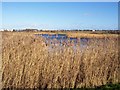
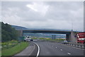
Reed beds
Extensive reed-beds fringe the lake in the park, with the A55 dual-carriageway in the distance. The water and reeds are among the last remnants of the salt-marsh and dune-slacks which pre-dated the modern urbanised coastline.
Image: © Jonathan Wilkins
Taken: 24 Jan 2008
0.14 miles

8
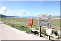
Pensarn Beach
The North Wales Coast Path and Pensarn Beach.
Image: © Jeff Buck
Taken: 5 Jul 2016
0.17 miles
10
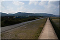
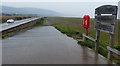
Wales Coast Path towards Llanddulas
Taken while walking along the Sea Wall.
Image: © Ian S
Taken: 16 Sep 2014
0.18 miles