IMAGES TAKEN NEAR TO
Pentredwr, LLANGOLLEN, LL20 8DH
Introduction
This page details the photographs taken nearby to LL20 8DH by members of the Geograph project.
The Geograph project started in 2005 with the aim of publishing, organising and preserving representative images for every square kilometre of Great Britain, Ireland and the Isle of Man.

There are currently over 7.5m images from over14,400 individuals and you can help contribute to the project by visiting https://www.geograph.org.uk
Image Map
Images are licensed for reuse under creativecommons.org/licenses/by-sa/2.0
Notes
- Clicking on the map will re-center to the selected point.
- The higher the marker number, the further away the image location is from the centre of the postcode.
Image Listing (9 Images Found)
Images are licensed for reuse under creativecommons.org/licenses/by-sa/2.0
Image
Details
Distance
1
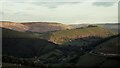
Looking south from the Horseshoe Pass
Early autumn morning on a fine day. The Horseshoe Pass is seen snaking its way across the right-hand mountain.
Image: © Eirian Evans
Taken: 21 Sep 2008
0.09 miles
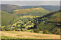
2
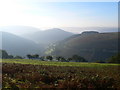
The Eglwyseg Valley
Looking along the Eglwyseg valley, an area to the north east of Llangollen, from the Horseshoe Pass which separates Llantysilio Mountain to the west from Cyrn-y-Brain to the east. The road travels in a horseshoe shape around the sides of the valley, giving the pass its English name. Its Welsh name is Bwlch yr Oernant which means “Pass of the Cold Stream".
Image: © David Dixon
Taken: 23 Jan 2019
0.12 miles
3
View from the Horseshoe Pass
View from the Horseshoe Pass to the limestone scars of Greigiau Eglwyseg.
Image: © Philip Halling
Taken: 10 Jun 2015
0.17 miles
4
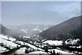
Horseshoe Pass view in 1995
View south east
Image: © Kevin Waterhouse
Taken: Unknown
0.18 miles
6
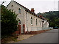
Capel Bethesda
The Calvinistic methodist chapel at Pentredwr, near Llangollen, which has now been converted into a house. It was built in 1812.
Image: © Eirian Evans
Taken: 22 Jul 2006
0.20 miles
7
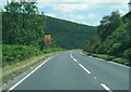
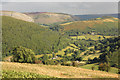
The Horseshoe Pass
View over the Horseshoe Pass above Pentredwr, the A542 can be seen contouring the hill in the foreground.
Image: © Philip Halling
Taken: 10 Jun 2015
0.20 miles
8
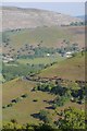
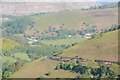
Horseshoe Pass
Horseshoe Pass and Pentredwr
Image: © Richard Croft
Taken: 17 Aug 2014
0.23 miles