IMAGES TAKEN NEAR TO
Glyn Ceiriog, LLANGOLLEN, LL20 7NN
Introduction
This page details the photographs taken nearby to LL20 7NN by members of the Geograph project.
The Geograph project started in 2005 with the aim of publishing, organising and preserving representative images for every square kilometre of Great Britain, Ireland and the Isle of Man.

There are currently over 7.5m images from over14,400 individuals and you can help contribute to the project by visiting https://www.geograph.org.uk
Image Map
Images are licensed for reuse under creativecommons.org/licenses/by-sa/2.0
Notes
- Clicking on the map will re-center to the selected point.
- The higher the marker number, the further away the image location is from the centre of the postcode.
Image Listing (8 Images Found)
Images are licensed for reuse under creativecommons.org/licenses/by-sa/2.0
Image
Details
Distance
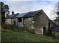
1
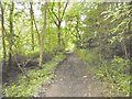
Pandy, trackbed
Through woodland next to Afon Ceiriog; once the Glyn Valley Tramway, used to access a granite quarry to the South. Now a footpath. http://www.glynvalleytramwaytrust.co.uk/
Image: © Mike Faherty
Taken: 3 Aug 2017
0.17 miles
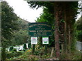
3
Ceiriog Valley Park
Caravans at the Ceiriog Valley Park.
Image: © Philip Halling
Taken: 6 Sep 2023
0.19 miles
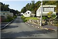
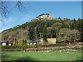
5
Ddol-hir Caravan Park
In the Ceiriog Valley.
Image: © Eirian Evans
Taken: 28 Sep 2007
0.20 miles
6
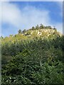
Craig y Pandy
A limestone outcrop above Pandy.
Image: © John Haynes
Taken: 9 Apr 2011
0.20 miles
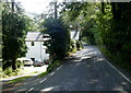
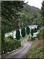
7
Ddol-Hir Caravan Park
Entrance to the caravan park between Glyn Ceiriog and Pandy.
Image: © Eirian Evans
Taken: 28 Sep 2007
0.21 miles