IMAGES TAKEN NEAR TO
Vivod, LLANGOLLEN, LL20 7LP
Introduction
This page details the photographs taken nearby to Vivod, LL20 7LP by members of the Geograph project.
The Geograph project started in 2005 with the aim of publishing, organising and preserving representative images for every square kilometre of Great Britain, Ireland and the Isle of Man.

There are currently over 7.5m images from over14,400 individuals and you can help contribute to the project by visiting https://www.geograph.org.uk
Image Map
Images are licensed for reuse under creativecommons.org/licenses/by-sa/2.0
Notes
- Clicking on the map will re-center to the selected point.
- The higher the marker number, the further away the image location is from the centre of the postcode.
Image Listing (7 Images Found)
Images are licensed for reuse under creativecommons.org/licenses/by-sa/2.0
Image
Details
Distance
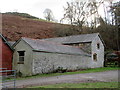
2
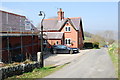
Foel Farm farmhouse
A brick built farmhouse, the red bricks are a mix of 3.125 & 3.25 inches red bricks from J C Edwards Ruabon Road brickworks in Trevor. The house and barn were built in 1888.
Image: © John Haynes
Taken: 12 Apr 2010
0.08 miles
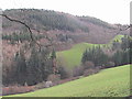
3
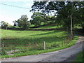
Grazings at Ty'n-y-celyn
Grazings near to the farm buildings. The traditional wrought iron fencing is again in evidence.
Image: © John Haynes
Taken: 7 Oct 2006
0.13 miles
4
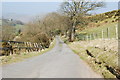
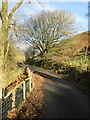
The lane down to Llangollen
Typical of the many lanes in this area.
Image: © John Haynes
Taken: 12 Apr 2010
0.15 miles
7
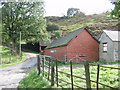
Farm buildings at Ty'n-y-celyn
Traditional buildings on this mixed livestock farm, it also has some part covered yards that look as if they could be pheasant rearing pens.
Image: © John Haynes
Taken: 7 Oct 2006
0.22 miles