IMAGES TAKEN NEAR TO
Bryn Parc, PRESTATYN, LL19 9UN
Introduction
This page details the photographs taken nearby to Bryn Parc, LL19 9UN by members of the Geograph project.
The Geograph project started in 2005 with the aim of publishing, organising and preserving representative images for every square kilometre of Great Britain, Ireland and the Isle of Man.

There are currently over 7.5m images from over14,400 individuals and you can help contribute to the project by visiting https://www.geograph.org.uk
Image Map (Loading...)


Getting Data...Please wait
Leaflet Map data © OpenStreetMap
Images are licensed for reuse under creativecommons.org/licenses/by-sa/2.0
Notes
- Clicking on the map will re-center to the selected point.
- The higher the marker number, the further away the image location is from the centre of the postcode.
Image Listing (14 Images Found)
Images are licensed for reuse under creativecommons.org/licenses/by-sa/2.0
Image
Details
Distance
1
Start of byway
South of Gronantby entrance to disused quarry with Pentre Farm on the left
Image: © Maggie Cox
Taken: 3 Apr 2013
0.07 miles
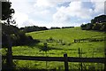
2
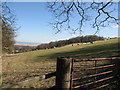
Grazing sheep and wood near Pentre Farm
Down the hill on the left is Gronant and in the distance is a holiday park on the North Wales Coast
Image: © Maggie Cox
Taken: 3 Apr 2013
0.11 miles
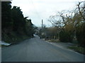
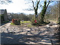
7
Public footpath
The path runs next to the pub garden.
Image: © Bob Harvey
Taken: 12 Sep 2018
0.20 miles
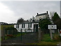
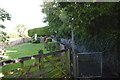
8
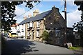
The Gronant Inn
The Letter G is missing from the sign on the end gable!
See Image for the defibrillator on the front wall.
Image: © Bob Harvey
Taken: 12 Sep 2018
0.20 miles
9
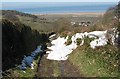
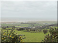
Byway to Gronant
Down the hill you can see Gronant. On the hillside to the left is Coed Bell Wood to the right of which, down on the flat, you can just see a train on the Chester to Holyhead railway. In the far distance you can see a windfarm offshore.
Image: © Maggie Cox
Taken: 3 Apr 2013
0.21 miles