IMAGES TAKEN NEAR TO
Pendre Avenue, PRESTATYN, LL19 9SL
Introduction
This page details the photographs taken nearby to Pendre Avenue, LL19 9SL by members of the Geograph project.
The Geograph project started in 2005 with the aim of publishing, organising and preserving representative images for every square kilometre of Great Britain, Ireland and the Isle of Man.

There are currently over 7.5m images from over14,400 individuals and you can help contribute to the project by visiting https://www.geograph.org.uk
Image Map
Images are licensed for reuse under creativecommons.org/licenses/by-sa/2.0
Notes
- Clicking on the map will re-center to the selected point.
- The higher the marker number, the further away the image location is from the centre of the postcode.
Image Listing (36 Images Found)
Images are licensed for reuse under creativecommons.org/licenses/by-sa/2.0
Image
Details
Distance
1
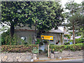
Plas Ifan, Fforddlas
A former chapel, converted to a B&B which specialises in providing accommodation for walkers starting or finishing Offa's Dyke Path.
Image: © John Allan
Taken: 1 Jul 2019
0.04 miles
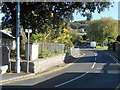
2
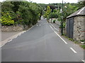
Fforddlas, Prestatyn and a small stone building
Looking south east along Fforddlas, which is also Offa's Dyke Long Distance Path. There is an Ordnance Survey bench mark on the small stone building on the far side of the wooden doors - Image
Image: © John S Turner
Taken: 28 Aug 2012
0.05 miles
3
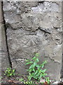
Bench mark in Fforddlas, Prestatyn
This Ordnance Survey bench mark is on a small stone building on the south west side of Fforddlas, Prestatyn. See also Image
Image: © John S Turner
Taken: 28 Aug 2012
0.06 miles
4
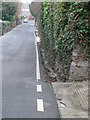
Fforddlas, Prestatyn
Fforddlas is the only street in Prestatyn which retains the open gutters which at one time ran all the way down the High Street.
Image: © Eirian Evans
Taken: 11 Jan 2008
0.10 miles
5
Plas Ifan, Prestatyn
This cottage of Fforddlas, Prestatyn, is where the first Calvinistic Methodist meeting place was founded in 1770. Achapel was built here in the early 1800's and this doubled up as a school by the 1850's. When Rehoboth chapel opened in 1863, this became a private house. It now offers bed and breakfast accommodation.
Image: © Eirian Evans
Taken: 11 Jan 2008
0.11 miles
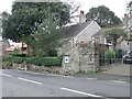
6
Fforddlas, Prestatyn and an Edward VII postbox
Looking along Fforddlas, Prestatyn, which is also part of the Offa's Dyke Long Distance Path. There is an Edward VII post-box set into a brick wall on the left, and opposite Pendle Avenue - Image Also there is an Ordnance Survey bench mark cut into the wall below the post-box - Image
Image: © John S Turner
Taken: 28 Aug 2012
0.11 miles
8
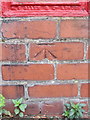
Bench mark in Fforddlas, Prestatyn
This Ordnance Survey bench mark is cut into a brick wall below an Edward VII post-box in Fforddlas, Prestatyn - Image It is alongside the Offa's Dyke Long Distance Path, and opposite Pendle Avenue - Image
Image: © John S Turner
Taken: 28 Aug 2012
0.12 miles
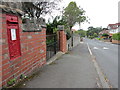
9
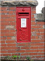
Edward VII post-box in Fforddlas, Prestatyn
This Edward VII post-box is set into a brick wall in Fforddlas, Prestatyn. It is alongside the Offa's Dyke Long Distance Path, and opposite Pendle Avenue. There is an Ordnance Survey bench mark cut into the wall below the post-box - Image
Image: © John S Turner
Taken: 28 Aug 2012
0.12 miles
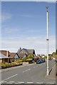
10
Offa's Dyke National Trail as it leaves Prestatyn
Image: © Row17
Taken: 28 Sep 2011
0.12 miles