IMAGES TAKEN NEAR TO
Glyn Avenue, PRESTATYN, LL19 9NN
Introduction
This page details the photographs taken nearby to Glyn Avenue, LL19 9NN by members of the Geograph project.
The Geograph project started in 2005 with the aim of publishing, organising and preserving representative images for every square kilometre of Great Britain, Ireland and the Isle of Man.

There are currently over 7.5m images from over14,400 individuals and you can help contribute to the project by visiting https://www.geograph.org.uk
Image Map (Loading...)


Getting Data...Please wait
Leaflet Map data © OpenStreetMap
Images are licensed for reuse under creativecommons.org/licenses/by-sa/2.0
Notes
- Clicking on the map will re-center to the selected point.
- The higher the marker number, the further away the image location is from the centre of the postcode.
Image Listing (73 Images Found)
Images are licensed for reuse under creativecommons.org/licenses/by-sa/2.0
Image
Details
Distance
1
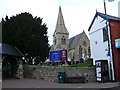
Eglwys Crist ym Mhrestatyn / Christ Church in Prestatyn
Eglwys Crist ym Mhrestatyn / Christ Church in Prestatyn
Image: © Ian Medcalf
Taken: 5 Apr 2010
0.07 miles
2
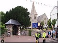
Christ Church
On High Street, waiting for the bride.
Image: © Peter Teal
Taken: 9 Jun 2006
0.08 miles
3
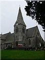
Christ Church, Prestatyn
The parish church for Prestatyn, which dates from 1863
Image: © Eirian Evans
Taken: 13 Jan 2008
0.08 miles
5
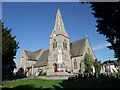
Christ Church, Prestatyn
A brief history at http://www.zyworld.com/RevDQB/PrestatynParish/PrestatynPDF/ChristChurchHistory.pdf
Image: © Tim Heaton
Taken: 12 May 2009
0.09 miles
6
Ysgol Bodnant, Prestatyn
Junior school on the eastern fringes of Prestatyn.
Image: © Eirian Evans
Taken: 11 Jan 2008
0.10 miles
7

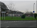
Prestatyn High Street
Lay By at the side of Christ Church, trees in the church grounds.
Image: © Peter Teal
Taken: 18 Jul 2006
0.10 miles
8
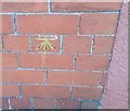
Ordnance Survey Cut Mark
This OS cut mark can be found on a building south side of Ffordd Llys Nant. It marks a point 7.580m above mean sea level.
Image: © Adrian Dust
Taken: 15 Sep 2019
0.11 miles
9
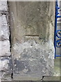
Bench mark on Yr Eglwys Fethodistaidd gatepost
This Ordnance Survey bench mark is on one of the gateposts in front of the Bethel Methodist Chapel in Stryd Fawr/High Street, Prestatyn. See also Image
Image: © John S Turner
Taken: 28 Aug 2012
0.11 miles
10
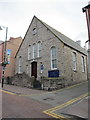
Yr Eglwys Fethodistaidd in Stryd Fawr/High Street, Prestatyn
Looking across Stryd Fawr/High Street towards the Bethel Methodist Church. There is an Ordnance Survey bench mark on the gatepost to the left of the nearest gate - Image
Image: © John S Turner
Taken: 28 Aug 2012
0.11 miles