IMAGES TAKEN NEAR TO
Tan Yr Allt, PRESTATYN, LL19 8PT
Introduction
This page details the photographs taken nearby to Tan Yr Allt, LL19 8PT by members of the Geograph project.
The Geograph project started in 2005 with the aim of publishing, organising and preserving representative images for every square kilometre of Great Britain, Ireland and the Isle of Man.

There are currently over 7.5m images from over14,400 individuals and you can help contribute to the project by visiting https://www.geograph.org.uk
Image Map
Images are licensed for reuse under creativecommons.org/licenses/by-sa/2.0
Notes
- Clicking on the map will re-center to the selected point.
- The higher the marker number, the further away the image location is from the centre of the postcode.
Image Listing (12 Images Found)
Images are licensed for reuse under creativecommons.org/licenses/by-sa/2.0
Image
Details
Distance
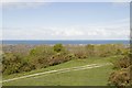
1
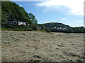
Elevated bungalow above a hay meadow below Tan-yr-allt
Backing up to a rockface this bungalow has a great outlook to its front, over June hay meadows towards Prestatyn Hillside and the distant coast.
Image: © Jeremy Bolwell
Taken: 20 Jun 2010
0.08 miles
2
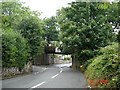
Disused railway line at Meliden
Disused railway bridge at Meliden
Image: © Dot Potter
Taken: 28 Jul 2005
0.11 miles
3
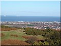
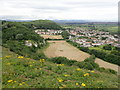
Graig Fawr View
From the upper slopes of Graif Fawr, looking over the town of Prestatyn with the windfarms clearly visible out to sea
Image: © Dot Potter
Taken: 14 Jan 2006
0.11 miles
4
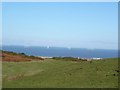
Graig Fawr to the windfarms
A view of the windfarms taken from Graig Fawr which is in the foreground
Image: © Dot Potter
Taken: 14 Jan 2006
0.11 miles
5
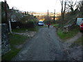
Steep lane in Tan-yr-allt
Sunlight illuminates the lowland below but this lane in a deep cleft is now cold and wintery.
Image: © Jeremy Bolwell
Taken: 2 Jan 2012
0.12 miles
6
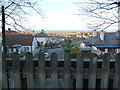
View to Meliden from the Offa's Dyke Path
Houses nestle below Graig Fawr, the furthest north of the Clwydian Range hill forts, while three tractors are cutting silage in the field
Image: © Eirian Evans
Taken: 22 Jul 2020
0.13 miles
7
View over part of Meliden from the old railway trackbed bridge
The elevation here permits a nice view towards the sea.
Image: © Jeremy Bolwell
Taken: 2 Jan 2012
0.13 miles
8
View towards Prestatyn from the Offa's Dyke path
The end of the path is in sight. It's just to the right of the leisure centre which is the grey and black building about 1/3 from the right.
Image: © Mark Anderson
Taken: 6 May 2019
0.16 miles
9
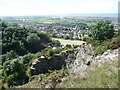
Above the old quarry near Tan-yr-allt
Apparently this area was heavily quarried, as well as being mined for copper and lead, the quarries closing in the mid 20th century, subsequently becoming habitats for birds and other wildlife. Offa's Dyke Path passes along this pathway above the cliffs.
Image: © Jeremy Bolwell
Taken: 20 Jun 2010
0.17 miles
10
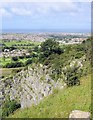
On the Offa's Dyke Path above Tan-yr-Allt
Prestatyn, on the Offa's Dyke Path above the quarry at Tan-yr-Allt.
Image: © Mike Harris
Taken: 26 Aug 2007
0.18 miles