IMAGES TAKEN NEAR TO
Llys Y Gadlas, PRESTATYN, LL19 8NW
Introduction
This page details the photographs taken nearby to Llys Y Gadlas, LL19 8NW by members of the Geograph project.
The Geograph project started in 2005 with the aim of publishing, organising and preserving representative images for every square kilometre of Great Britain, Ireland and the Isle of Man.

There are currently over 7.5m images from over14,400 individuals and you can help contribute to the project by visiting https://www.geograph.org.uk
Image Map (Loading...)


Getting Data...Please wait
Leaflet Map data © OpenStreetMap
Images are licensed for reuse under creativecommons.org/licenses/by-sa/2.0
Notes
- Clicking on the map will re-center to the selected point.
- The higher the marker number, the further away the image location is from the centre of the postcode.
Image Listing (11 Images Found)
Images are licensed for reuse under creativecommons.org/licenses/by-sa/2.0
Image
Details
Distance
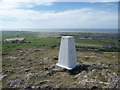
1
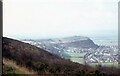
Westwards lies Graig Fawr - Meliden, Denbighshire
The prominent feature to the west in this photo is the National Trust-owned open space of Graig Fawr. Standing immediately south of the village of Gallt Melyd/Meliden there is a viewpoint looking north to Prestatyn and westwards towards Rhyl. There is a car park on the southern edge of the area. This photo was taken from the Offa's Dyke Path where it follows the Prestatyn Hillside Nature Reserve. It was the start of my solitary north to south walk on the Dyke Path after spending an overnight at a b and b (bed and breakfast) in Prestatyn. Time photo taken not available.
Image: © Martin Richard Phelan
Taken: Unknown
0.16 miles
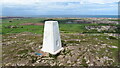
2
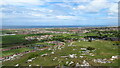
On Graig Fawr - view over Meliden & beyond towards Prestatyn
Image: © Richard Park
Taken: 12 May 2021
0.16 miles
3
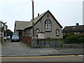
Salem Methodist Chapel, Meliden
Welsh chapel in the middle of Meliden.
Image: © Eirian Evans
Taken: 11 Jan 2008
0.17 miles
4
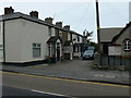
Cottages, Meliden
Cottages next to the Welsh Methodist chapel in Meliden.
Image: © Eirian Evans
Taken: 11 Jan 2008
0.17 miles
7
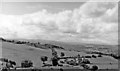
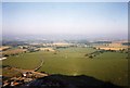
Western panorama to Snowdonia from Graig Fawr, Meliden 1951
Heading westward on the A547 road at Meliden near Prestatyn in Flintshire (as it was then), on a fine day the magnificent panorama of Snowdonia unfolded. In the middle distance the Pen-y-Mwddwl and Mynydd Llanellan ranges in Denbighshire of about 1,000 ft., then far on the horizon the 3,500 ft. Carnedd peaks west of the Conwy Valley and east of Snowdon itself. (Cf. Image).
Image: © Ben Brooksbank
Taken: 5 Aug 1951
0.17 miles
8
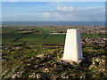
Graig Fawr trig point near Prestatyn
This hilltop provides extensive views over Meliden and Prestatyn to the coast.
Image: © Jeremy Bolwell
Taken: 20 Jun 2010
0.18 miles
9
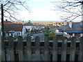
View over part of Meliden from the old railway trackbed bridge
The elevation here permits a nice view towards the sea.
Image: © Jeremy Bolwell
Taken: 2 Jan 2012
0.18 miles
10
Dawn on Graig Fawr as it casts its shadow on the land
Image: © Iain Lees
Taken: 12 Sep 1992
0.18 miles