IMAGES TAKEN NEAR TO
Hafod Y Mor, PRESTATYN, LL19 7HJ
Introduction
This page details the photographs taken nearby to Hafod Y Mor, LL19 7HJ by members of the Geograph project.
The Geograph project started in 2005 with the aim of publishing, organising and preserving representative images for every square kilometre of Great Britain, Ireland and the Isle of Man.

There are currently over 7.5m images from over14,400 individuals and you can help contribute to the project by visiting https://www.geograph.org.uk
Image Map
Images are licensed for reuse under creativecommons.org/licenses/by-sa/2.0
Notes
- Clicking on the map will re-center to the selected point.
- The higher the marker number, the further away the image location is from the centre of the postcode.
Image Listing (79 Images Found)
Images are licensed for reuse under creativecommons.org/licenses/by-sa/2.0
Image
Details
Distance
1
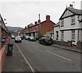
Hafod Road, Prestatyn
From the corner of Marine Road along Hafod Road towards Warren Road and Caradoc Road.
Image: © Jaggery
Taken: 9 Feb 2017
0.04 miles
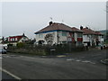
2
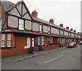
East side of Hafod Road, Prestatyn
Long row of houses viewed from the corner of Marine Road.
Image: © Jaggery
Taken: 9 Feb 2017
0.04 miles
3
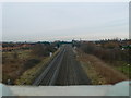
Chester to Holyhead railway line
Looking westwards along the railway line from the A549 bridge. Next stop, Prestatyn, then Rhyl.
Image: © Eirian Evans
Taken: 11 Jan 2008
0.05 miles
4
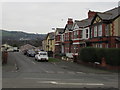
Warren Road, Prestatyn
Viewed from Marine Road. Warren Road leads to Caradoc Road.
Image: © Jaggery
Taken: 9 Feb 2017
0.06 miles
5
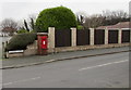
Queen Elizabeth II postbox, Warren Road, Prestatyn
In a brick pillar near the corner of Marine Drive.
Image: © Jaggery
Taken: 9 Feb 2017
0.09 miles
6
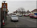
Ysgol/School warning sign, Marine Road, Prestatyn
Bilingual (Welsh/English) sign on the approach to Ysgol Gymunedol Bodnant/Bodnant Community School. http://www.geograph.org.uk/photo/5278633
Image: © Jaggery
Taken: 9 Feb 2017
0.09 miles
7
A548 Prestatyn Road, Prestatyn
Viewed from the Marine Road East junction, were the A548 Marine Road becomes
the A548 Prestatyn Road ahead. A nearby sign pointing this way shows Flint 14 (miles).
Image: © Jaggery
Taken: 9 Feb 2017
0.09 miles
8
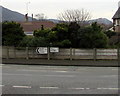
A548 distances from Prestatyn
Opposite the Marine Road East junction, the sign is near the point where the A548 Marine Road
becomes the A548 Prestatyn Road, 3 miles from Rhyl, 14 miles from Flint (Fflint in Welsh).
Image: © Jaggery
Taken: 9 Feb 2017
0.10 miles
9
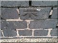
Ordnance Survey Cut Mark
This OS cut mark can be found on the NE parapet of the railway bridge. It marks a point 11.040m above mean sea level.
Image: © Adrian Dust
Taken: 15 Sep 2019
0.10 miles
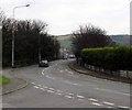
10
Warren Drive, Prestatyn
Warren Drive is on the corner of Barkby Avenue and the A548, on the north side of the railway
Image: © Eirian Evans
Taken: 11 Jan 2008
0.10 miles