IMAGES TAKEN NEAR TO
Llys Dafydd, RHYL, LL18 5FS
Introduction
This page details the photographs taken nearby to Llys Dafydd, LL18 5FS by members of the Geograph project.
The Geograph project started in 2005 with the aim of publishing, organising and preserving representative images for every square kilometre of Great Britain, Ireland and the Isle of Man.

There are currently over 7.5m images from over14,400 individuals and you can help contribute to the project by visiting https://www.geograph.org.uk
Image Map
Images are licensed for reuse under creativecommons.org/licenses/by-sa/2.0
Notes
- Clicking on the map will re-center to the selected point.
- The higher the marker number, the further away the image location is from the centre of the postcode.
Image Listing (6 Images Found)
Images are licensed for reuse under creativecommons.org/licenses/by-sa/2.0
Image
Details
Distance
1
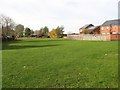
Green space
Amenity space off Ffordd Nant.
Image: © Jonathan Wilkins
Taken: 11 Nov 2016
0.12 miles
2
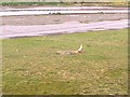
Mud flats on the banks of the River Clwyd
Image: © David and Rachel Landin
Taken: 30 Jul 2005
0.12 miles
3
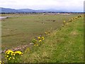
Fields alongside river estuary
These fields are by the River Clwyd
Image: © David and Rachel Landin
Taken: 30 Jul 2005
0.12 miles
4
Kinmel Bay Church
Evangelical Church on St Asaph Avenue.
Image: © Eirian Evans
Taken: 21 Mar 2012
0.19 miles
5
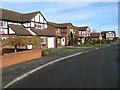
Ffordd Nant
New housing pressing into the green of the morfa south of Kinmel Bay.
Image: © Jonathan Wilkins
Taken: 11 Nov 2016
0.20 miles
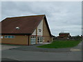
6
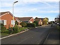
Ffordd Graiglun
Bungalows on the housing estate.
Image: © Jonathan Wilkins
Taken: 11 Nov 2016
0.22 miles