IMAGES TAKEN NEAR TO
The Grove, RHYL, LL18 3NE
Introduction
This page details the photographs taken nearby to The Grove, LL18 3NE by members of the Geograph project.
The Geograph project started in 2005 with the aim of publishing, organising and preserving representative images for every square kilometre of Great Britain, Ireland and the Isle of Man.

There are currently over 7.5m images from over14,400 individuals and you can help contribute to the project by visiting https://www.geograph.org.uk
Image Map
Images are licensed for reuse under creativecommons.org/licenses/by-sa/2.0
Notes
- Clicking on the map will re-center to the selected point.
- The higher the marker number, the further away the image location is from the centre of the postcode.
Image Listing (38 Images Found)
Images are licensed for reuse under creativecommons.org/licenses/by-sa/2.0
Image
Details
Distance
1
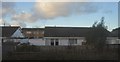
Highfield Park Post Office and Convenience Store
Image: © Eirian Evans
Taken: 2 May 2012
0.04 miles
2
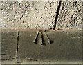
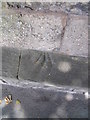
Ordnance Survey Cut Mark
This OS cut mark can be found on the wall of No25 Highfield Park. It marks a point 7.795m above mean sea level.
Image: © Adrian Dust
Taken: 13 Sep 2019
0.09 miles
3
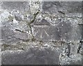
Ordnance Survey Benchmark
This damaged OS benchmark can be found on the wall at the junction of Russell Road & Conwy Street. It marked a point 25.1ft above mean sea level.
Image: © Adrian Dust
Taken: 13 Sep 2019
0.09 miles
4
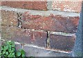
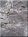
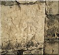
Obscured benchmark on Russell Road, Rhyl
This benchmark is located on the NW side of Russell Road & close to the junction with Conwy Street. The mark is not recorded in the current OS database but is shown on an 1871 map of the area at a height of 25.1ft above the Liverpool datum. The mark is located on top of a wall which has a more recent wall built on top of it. The mark is therefore partially obscured. It is therefore difficult to classify the type of mark as it could be a rivet, pivot or indeed a toppled cut mark.
Image: © Meirion
Taken: 28 Jun 2011
0.09 miles
5
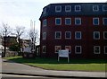
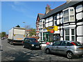
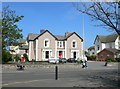
Russell House, Rhyl
Denbighshire council offices on Churton Road.
Image: © Eirian Evans
Taken: 2 May 2012
0.10 miles
6
Ordnance Survey Cut Mark
This OS cut mark can be found on the wall SE side of Russell Road. It marks a point 8.281m above mean sea level.
Image: © Adrian Dust
Taken: 13 Sep 2019
0.11 miles
7
Benchmark on Russell Road, Rhyl
This benchmark is located on the SE side of Russell Road in Rhyl and it is shown in the current Ordnance Survey database at a height of 11.2441m above the Newlyn datum.
Image: © Meirion
Taken: 14 Oct 2011
0.11 miles
8
Rhianfa Veterinary Centre
Veterinary service for small animals and horses.
Image: © Eirian Evans
Taken: 2 May 2012
0.12 miles
9
Ordnance Survey Cut Mark
This OS cut mark can be found on the wall between Nos79 & 81 Russell Road. It marks a point 7.480m above mean sea level.
Image: © Adrian Dust
Taken: 13 Sep 2019
0.13 miles