
IMAGES TAKEN NEAR TO
Vicarage Lane, RHYL, LL18 2UE
Introduction
This page details the photographs taken nearby to Vicarage Lane, LL18 2UE by members of the Geograph project.
The Geograph project started in 2005 with the aim of publishing, organising and preserving representative images for every square kilometre of Great Britain, Ireland and the Isle of Man.

There are currently over 7.5m images from over14,400 individuals and you can help contribute to the project by visiting https://www.geograph.org.uk
Image Map
Images are licensed for reuse under creativecommons.org/licenses/by-sa/2.0
Notes
- Clicking on the map will re-center to the selected point.
- The higher the marker number, the further away the image location is from the centre of the postcode.
Image Listing (117 Images Found)
Images are licensed for reuse under creativecommons.org/licenses/by-sa/2.0
Image
Details
Distance
1
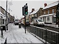
Snow in Rhuddlan Village
Looking down the High Street to the Kings Head
Image: © Alwyn Bradford
Taken: 26 Nov 2010
0.04 miles
2
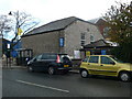
Goshen Chapel, Rhuddlan
Built as a congregational Chapel in 1855, it is now an Evangelical Church. It is sited on the main road through the middle of Rhuddlan.
Image: © Eirian Evans
Taken: 9 Nov 2007
0.04 miles
3
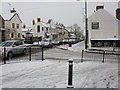
Snow in Rhuddlan Village
Looking down the High Street, traffic going slow because of the snow.
Image: © Alwyn Bradford
Taken: 26 Nov 2010
0.05 miles
4
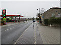
Rhyl Road by Goshen Chapel and Texaco petrol station
Looking north east along Rhyl Road with the Goshen/Gosen Chapel on the right. The old chapel is now the Rhuddlan Evangelical Church. There is a date plaque on the end wall with a date that has been interpreted as 1855, however, the last two numbers are different, and I believe the date is 1835. The Chapels Heritage Society website refers to the chapel being established in the early 1830s, which seems to confirm my opinion - "As with the Calvinistic Methodists the Independents' mother church, Gosen, which had been established in the early 1830s was in Rhuddlan." http://www.capeli.org.uk/uploads/local_25_rhyl.pdf See also Image
Image: © John S Turner
Taken: 1 Nov 2013
0.06 miles
5
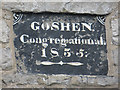
Date stone on the Goshen/Gosen Chapel
This date stone is on the south face of the old chapel. Although the date is not immediately obvious, the last two figures are different, and I believe the date is 1835. The Chapels Heritage Society website says: "As with the Calvinistic Methodists the Independents' mother church, Gosen, which had been established in the early 1830s was in Rhuddlan." This seems to confirm my opinion. http://www.capeli.org.uk/uploads/local_25_rhyl.pdf See also: Image
Image: © John S Turner
Taken: 1 Nov 2013
0.06 miles
6
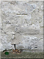
Bench mark on the Goshen/Gosen Chapel
This bench mark is on the west face of the chapel alongside Rhyl Road. See also: Image
Image: © John S Turner
Taken: 1 Nov 2013
0.06 miles
7
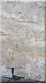
Ordnance Survey Cut Mark
This OS cut mark can be found on the chapel SE side of Rhyl Road. It marks a point 14.652m above mean sea level.
Image: © Adrian Dust
Taken: 13 Sep 2019
0.06 miles
8
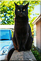
William
A cat that went part feral in the locality after his owner died, living rough, and surviving through the kindness of local villagers until finally being adopted. A real character and a survivor.
Image: © Mike Searle
Taken: 13 May 2018
0.06 miles
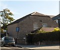
10

The King's Head, Rhuddlan
Public house on the High Street in Rhuddlan.
Image: © Eirian Evans
Taken: 9 Nov 2007
0.07 miles