IMAGES TAKEN NEAR TO
Queen Street, RHYL, LL18 1SB
Introduction
This page details the photographs taken nearby to Queen Street, LL18 1SB by members of the Geograph project.
The Geograph project started in 2005 with the aim of publishing, organising and preserving representative images for every square kilometre of Great Britain, Ireland and the Isle of Man.

There are currently over 7.5m images from over14,400 individuals and you can help contribute to the project by visiting https://www.geograph.org.uk
Image Map
Images are licensed for reuse under creativecommons.org/licenses/by-sa/2.0
Notes
- Clicking on the map will re-center to the selected point.
- The higher the marker number, the further away the image location is from the centre of the postcode.
Image Listing (207 Images Found)
Images are licensed for reuse under creativecommons.org/licenses/by-sa/2.0
Image
Details
Distance
1
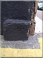
Benchmark at 55 Queens Street, Rhyl
This benchmark is located on the NW face of No. 55 Queens Street in Rhyl and it is shown in the current Ordnance Survey database at a height of 6.6047m above the Newlyn datum.
Image: © Meirion
Taken: 14 Oct 2011
0.01 miles
2
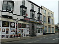
Fast food outlets, Queen Street
Kareem's Curry House (Best in Wales!) and Bella Pizza - both closed by 2016.
Image: © Eirian Evans
Taken: 21 Mar 2012
0.01 miles
3
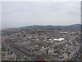
Rhyl from the Sky Tower
Rhyl, taken from the top of the Sky Tower
Image: © BrianPritchard
Taken: 24 Jun 2008
0.01 miles
4
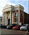
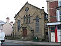
Sussex Street Christian Centre
An impossing chapel on Sussex Street in Rhyl.
Image: © Philip Halling
Taken: 26 May 2021
0.03 miles
5
Islamic Centre, Rhyl
A 19th century Baptist chapel which was bought by the small local Islamic community in the Rhyl area and which had now been converted into the Islamic Cultural Centre. It is in Water Street, Rhyl
Image: © Eirian Evans
Taken: 11 Jan 2008
0.04 miles
6
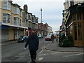
Water Street, Rhyl
Leading up to the promenade. The Sky Tower, which opened in 1989, can be seen over the buildings.
Image: © Eirian Evans
Taken: 11 Jan 2008
0.04 miles
8
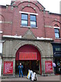
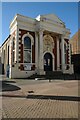
Queens Arcade, Rhyl
The Queen's Arcade in Rhyl dates back to Victorian times. At one time it housed a zoo, a waxworks, a ballroom, 40 shops, a winter Garden, a Theatre, a Native Village, and an underwater imitation of Venice with real canals.
Image: © Eirian Evans
Taken: 11 Jan 2008
0.04 miles
9
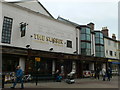
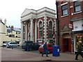
The Sussex, Rhyl
A Wetherspoon pub, located at the Old Comrades Memorial Club on Sussex Street.
Image: © Eirian Evans
Taken: 21 Mar 2012
0.04 miles