IMAGES TAKEN NEAR TO
The Roe, ST. ASAPH, LL17 0NA
Introduction
This page details the photographs taken nearby to The Roe, LL17 0NA by members of the Geograph project.
The Geograph project started in 2005 with the aim of publishing, organising and preserving representative images for every square kilometre of Great Britain, Ireland and the Isle of Man.

There are currently over 7.5m images from over14,400 individuals and you can help contribute to the project by visiting https://www.geograph.org.uk
Image Map (Loading...)


Getting Data...Please wait
Leaflet Map data © OpenStreetMap
Images are licensed for reuse under creativecommons.org/licenses/by-sa/2.0
Notes
- Clicking on the map will re-center to the selected point.
- The higher the marker number, the further away the image location is from the centre of the postcode.
Image Listing (54 Images Found)
Images are licensed for reuse under creativecommons.org/licenses/by-sa/2.0
Image
Details
Distance
1
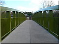
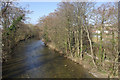
Pont Begard - St Asaph's new footbridge
Looking across the brand new footbridge over the river Elwy in St Asaph, which was installed in September 2007. The bridge connects the east and west sides of the river on almost exactly the same site as a bridge which existed in 1611. The new bridge continues the popular cycle track and provides a safe route to school for many pupils who live in upper St. Asaph who attend Ysgol Esgob Morgan
Image: © Eirian Evans
Taken: 9 Nov 2007
0.04 miles
2
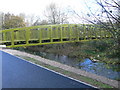
Pont Begard - foot and bicycle bridge over the Elwy, St Asaph
The bridge, named Pont Begard after St. Asaph's twin town, is designed to connect east and west St. Asaph. It's certainly built to last which is wise given that, in the recent past, floodwaters have risen as high as the bicycle path that is shown on the photo. It's strong enough and wide enough to take a vehicle in an emergency.
Image: © Eirian Evans
Taken: 9 Nov 2007
0.04 miles
7
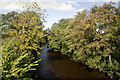
Afon Elwy, St Asaph
The Afon Elwy is seen here from the bridge in St Asaph, looking downstream towards its confluence with the River Clwyd. The Welsh name for this diminutive city, Llanelwy, is derived from the river.
Image: © Stephen McKay
Taken: 6 Mar 2011
0.08 miles
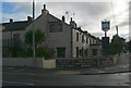
8
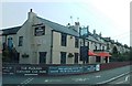
Mini-roundabout, St Asaph
This roundabout links the A525/ B5381 and St Asaph Bridge.
Image: © David Bremner
Taken: 20 Jul 2021
0.09 miles
10
Skate ramp at Mill Street recreation area, St Asaph
Image: © Gary Rogers
Taken: 16 Oct 2016
0.10 miles