IMAGES TAKEN NEAR TO
Mold Road, DENBIGH, LL16 4DU
Introduction
This page details the photographs taken nearby to Mold Road, LL16 4DU by members of the Geograph project.
The Geograph project started in 2005 with the aim of publishing, organising and preserving representative images for every square kilometre of Great Britain, Ireland and the Isle of Man.

There are currently over 7.5m images from over14,400 individuals and you can help contribute to the project by visiting https://www.geograph.org.uk
Image Map
Images are licensed for reuse under creativecommons.org/licenses/by-sa/2.0
Notes
- Clicking on the map will re-center to the selected point.
- The higher the marker number, the further away the image location is from the centre of the postcode.
Image Listing (3 Images Found)
Images are licensed for reuse under creativecommons.org/licenses/by-sa/2.0
Image
Details
Distance
1
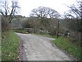
Bridleway by Ty-newydd
The well signposted bridleway from this quiet country lane passes Ty-newydd as it heads downhill towards the busy A541.
Image: © John S Turner
Taken: 13 Feb 2007
0.06 miles
2
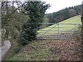
Field Gate and Forestry
Viewed from the minor road near Ty Newydd. The field is grazed by sheep, and at the far side is a forestry plantation. Offas Dyke LDP is on the other side of the wood.
Image: © John S Turner
Taken: 13 Feb 2007
0.15 miles
3
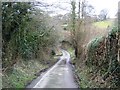
Country Lane
Just one of many narrow country lanes in the Welsh hills, this one is east of Tremeirchion. Looking downhill towards where a small stream crosses under the road.
Image: © John S Turner
Taken: 13 Feb 2007
0.25 miles