IMAGES TAKEN NEAR TO
Love Lane, DENBIGH, LL16 3LU
Introduction
This page details the photographs taken nearby to Love Lane, LL16 3LU by members of the Geograph project.
The Geograph project started in 2005 with the aim of publishing, organising and preserving representative images for every square kilometre of Great Britain, Ireland and the Isle of Man.

There are currently over 7.5m images from over14,400 individuals and you can help contribute to the project by visiting https://www.geograph.org.uk
Image Map
Images are licensed for reuse under creativecommons.org/licenses/by-sa/2.0
Notes
- Clicking on the map will re-center to the selected point.
- The higher the marker number, the further away the image location is from the centre of the postcode.
Image Listing (281 Images Found)
Images are licensed for reuse under creativecommons.org/licenses/by-sa/2.0
Image
Details
Distance
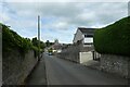
1
The Old Prison, Denbigh
On Love Lane, on the way up to the castle from the town centre.
Image: © Eirian Evans
Taken: 11 Nov 2010
0.01 miles
2
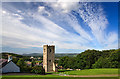
Denbigh Castle - St Hilary's Chapel tower
The C14 tower of St Hilary's is all that now remains of the chapel that was mostly demolished in 1923. Built for the inhabitants of the castle and fortified borough (whose official church was St Marcella's over a mile away), it continued to serve the town until Victorian times.
Image: © Mike Searle
Taken: 27 Jul 2012
0.04 miles
3
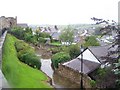
West Denbigh from Castle Lane
The large building in the centre is the Old School Image
Image: © Eirian Evans
Taken: 11 Nov 2010
0.05 miles
4
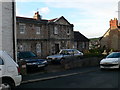
Glas Meadow Lane
Looking along Glas Meadow Lane off Smithfield Road.
Image: © DS Pugh
Taken: 7 Aug 2020
0.05 miles
5
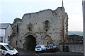
The Burgess Gate in Denbigh town walls
Image: © Roger Davies
Taken: 25 Apr 2014
0.05 miles
6
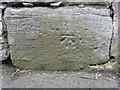
Bench mark on a wall junction in Castle Lane
This Ordnance Survey bench mark is at a distinct junction in the stone wall alongside Castle Lane. See also Image
Image: © John S Turner
Taken: 3 May 2016
0.06 miles
7
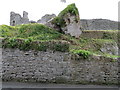
Castle Lane wall, the castle and a bench mark
Looking across Castle Lane with Denbigh Castle in the background. There is an Ordnance Survey bench mark on the large stone block at the bottom of the wall junction - Image
Image: © John S Turner
Taken: 3 May 2016
0.06 miles
8
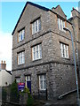
The Old School, Love Lane
Now converted into flats.
Image: © Eirian Evans
Taken: 11 Nov 2010
0.06 miles
9
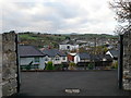
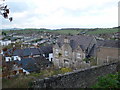
Looking down on Denbigh from Castle Lane
The western side of the town, mostly residential, but the white building at the centre is Caledfryn, part of the County headquarters.
Image: © Eirian Evans
Taken: 11 Nov 2010
0.06 miles