IMAGES TAKEN NEAR TO
Llanbedr Dyffryn Clwyd, RUTHIN, LL15 1UW
Introduction
This page details the photographs taken nearby to LL15 1UW by members of the Geograph project.
The Geograph project started in 2005 with the aim of publishing, organising and preserving representative images for every square kilometre of Great Britain, Ireland and the Isle of Man.

There are currently over 7.5m images from over14,400 individuals and you can help contribute to the project by visiting https://www.geograph.org.uk
Image Map
Images are licensed for reuse under creativecommons.org/licenses/by-sa/2.0
Notes
- Clicking on the map will re-center to the selected point.
- The higher the marker number, the further away the image location is from the centre of the postcode.
Image Listing (11 Images Found)
Images are licensed for reuse under creativecommons.org/licenses/by-sa/2.0
Image
Details
Distance
1
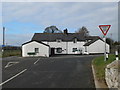
Pentre Smithy
Now converted into houses, the smithy stands on a crossroads between Ruthin and Llanbedr D.C.
Image: © Eirian Evans
Taken: 19 Feb 2011
0.01 miles
2
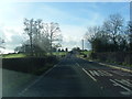
Junction of the A494 and B5429 at Pentre
The A494 sweeps round to the left and the B5429 to Graigfechan and Pentrecelyn goes off to the right.
Image: © Bob Walters
Taken: 17 Nov 2018
0.01 miles
3
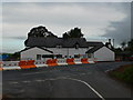
Pentre Smithy, near Ruthin
Pentre Smithy seen from the junction with the A494. The road in front of the Smithy, the A494, has been widened considerably of latet and the construction of a new culvert is under way.
Image: © Eirian Evans
Taken: 9 Oct 2007
0.04 miles
4
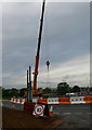
Road works at Pentre Smithy
Culvert replacement works at Pentre Smithy, between Ruthin and Llanbedr D.C.
Image: © Eirian Evans
Taken: 9 Oct 2007
0.06 miles
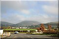
7
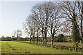
Farmland near Llanbedr Dyffryn Clwyd
The village of Llanbedr DC is visible across the fields.
Image: © David Medcalf
Taken: 25 Jan 2006
0.22 miles
8
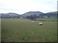
A rusty gateway, a bench mark, and a view to the hills
This field gateway is alongside the unnamed lane near Wern farm. The stone gatepost on the left has an Ordnance Survey bench mark cut into it - Image In the distance is Foel Fenlli part of the Clwydian range.
Image: © John S Turner
Taken: 18 Sep 2018
0.23 miles
9
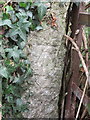
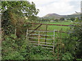
Bench mark near Wern Farm, east of Ruthin
This Ordnance Survey bench mark is on an old ivy-covered, and bramble protected gatepost, in an unnamed lane near Wern farm. See also Image
Image: © John S Turner
Taken: 18 Sep 2018
0.23 miles
10
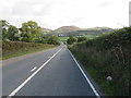
The A494 and a milestone
Looking east along the A494 towards the Clwydian Hills. On the right there is what remains of a milestone, which, according to old maps, once read 'Mold 9 Ruthin 1'. It appears to have lost a metal plate from the face, which may have been removed during the war. Image
Image: © John S Turner
Taken: 18 Sep 2018
0.23 miles