IMAGES TAKEN NEAR TO
The Park, RUTHIN, LL15 1PW
Introduction
This page details the photographs taken nearby to The Park, LL15 1PW by members of the Geograph project.
The Geograph project started in 2005 with the aim of publishing, organising and preserving representative images for every square kilometre of Great Britain, Ireland and the Isle of Man.

There are currently over 7.5m images from over14,400 individuals and you can help contribute to the project by visiting https://www.geograph.org.uk
Image Map
Images are licensed for reuse under creativecommons.org/licenses/by-sa/2.0
Notes
- Clicking on the map will re-center to the selected point.
- The higher the marker number, the further away the image location is from the centre of the postcode.
Image Listing (31 Images Found)
Images are licensed for reuse under creativecommons.org/licenses/by-sa/2.0
Image
Details
Distance
1
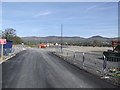
Site for new primary school at Ruthin
A new primary school is being built on the site of Glasdir farm - the farmhouse has been demolished.
Image: © Eirian Evans
Taken: 26 Mar 2017
0.15 miles
2
Ruthin auction mart
The auction which houses livestock sales
Image: © Dot Potter
Taken: 22 Jan 2006
0.15 miles
3
Stream diversion
This picture shows part of the Ruthin Flood Prevention Scheme. A stream ran under one of the main streets in Ruthin, and this caused flooding very often in the last few years which has now been alleviated by diverting the stream eastwards.
Image: © Eirian Evans
Taken: 12 Feb 2006
0.15 miles
4
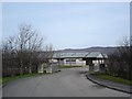
New school site entrance
A new primary school is being built on the site of Glasdir farm - the farmhouse has been demolished.
Image: © Eirian Evans
Taken: 26 Mar 2017
0.16 miles
5
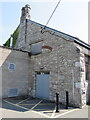
The west gable end of Ruthin Drill Hall/Youth Centre
The west gable of the former Drill Hall has some tall bricked-up arches of unknown purpose. See also: Image
Image: © John S Turner
Taken: 23 Jul 2014
0.17 miles
6
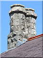
Twin chimneys on Ruthin Drill Hall/Youth Centre
These twin chimneys are at the west end of the old building.
Image: © John S Turner
Taken: 23 Jul 2014
0.17 miles
7
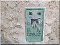
Ordnance Survey Flush Bracket S2842
This bracket can be found on the wall of a Youth Centre in Borthyn, Ruthin. The benchmark height is recorded as being 57.229 metres above sea level.
For more detail see : https://www.bench-marks.org.uk/bm14867
Image: © Peter Wood
Taken: 19 Nov 2018
0.17 miles
8
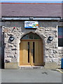
Entrance porch to Ruthin Drill Hall/Youth Centre
Image: © John S Turner
Taken: 23 Jul 2014
0.17 miles
9
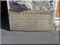
Foundation stone (left) on Ruthin Drill Hall/Youth Centre
This stone is on the left of the entrance porch and carries the name Mrs Mary Cornwallis West, of Ruthin Castle. See also: Image and Image
Image: © John S Turner
Taken: 23 Jul 2014
0.17 miles
10
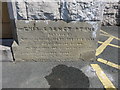
Foundation stone (right) on Ruthin Drill Hall/Youth Centre
This stone is on the right of the entrance porch and after some family history research I believe that part of the inscription reads:
THIS CORNER STONE
was laid by
Miss Adeline Mary Gregson Ellis.
The word 'Mary' is very clear, with a large space before 'Mary', so the name could not be that of her elder brother 'Richard George Gregson Ellis', who was the Lieutenant of the 1st Denbighshire Volunteer Corps., neither could it have been that of their mother, Mary Gregson Ellis, who died in 1888. Unfortunately the rest of the inscription, which probably includes the date, is so worn as to be illegible. See also: Image and Image
Image: © John S Turner
Taken: 23 Jul 2014
0.17 miles